A little cabin in the woods

Thick fog remains even after the rain stops between Snoqualmie Pass and White Pass

There’s a cabin halfway between Snoqualmie Pass and White Pass. On this leg of our journey, that cabin became a kind of holy grail.

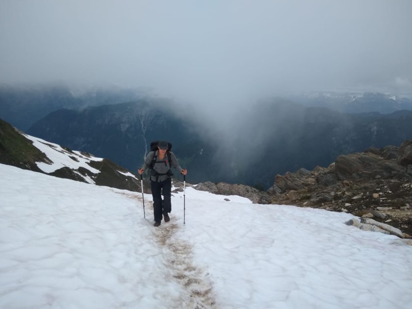
We knew it would rain last week, but we walked out of Snoqualmie Pass anyway. Other hikers stayed in hotels and hostels, drying out from the previous section and nursing arches and ankles. But we couldn’t let a couple of days of rain get in our way.

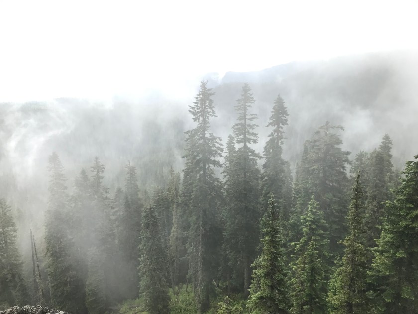
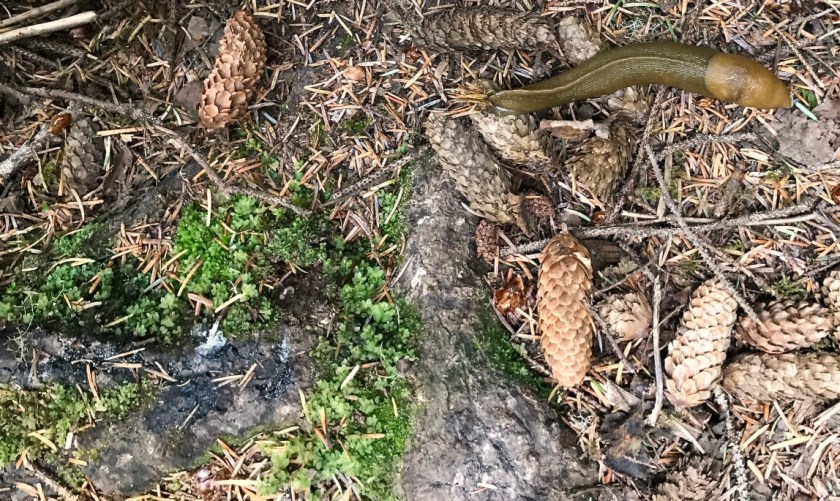
On Tuesday, the rain hit. At first it was only drizzle. Then it became a downpour. The wind picked up.

In a few stretches, we walked under power lines so high in voltage they buzzed. No trees sheltered us, and the rain blew sideways into our faces. Drops battered my jacket, finding my pitzips and soaking my shirt. It was about that moment when I started thinking about the cabin.

The app we use as a trail guide calls it “Mike Urich Cabin & Stream.” From the app we could see the cabin is at mile 305.6 and open for public use. It has a wood stove and a pit toilet or two out back.

The idea of four walls and a roof were intoxicating. A log cabin! It sounded sturdy. It sounded warm.

Then I opened the comments about the Mike Urich Cabin…

A screenshot from the app we use as a trail guide

The app allows users to comment on places along the trail. This comes in handy as the trail can change from week to week — seasonal streams dry up and campsites become buggy.

The reviews about the Urich place were all over the map.

“Watch out for the mice,” wrote one thruhiker.

Mice? I scoffed. There are mice everywhere! How bad can they be?

I read on.

“Nice spot to dry out and do some axe-throwing,” wrote Bearman’s Girlfriend.

In the middle of the downpour, I really focused on the “dryout” part of the comment. Then my eye caught on “axe-throwing.” Were we going to be dodging axes?

Then I read the thread about the “locals.”

“Some locals are here,” wrote one hiker.

“Be prepared that party people may be having their party until 3 a.m.,” commented another.

That, presumably, was a dig at the locals because hikers tent to pack it in around 8 or 9 p.m.

Someone named h.r. filled in the details: “Got here on a Saturday night. Some locals were partying HARD. A 45-year-old man got so hammered that he cried all night while he puked all over the cabin floor.”

“Hey [full name redacted] – did you read h.r.’s comment below? Was that you??? HAHA! Enjoy man!” wrote reddog.

Not only was it the kind of place someone might have a drunken epiphany and toss around axes, it was also the kind of place they’d get called out by their full name!

The cabin’s amenities were no better. The cabin’s wood stove, and biggest selling point might or might not have been attached to a clogged chimney that was ready to “burn the place down.”

And the toilets were likely very, very dirty. Someone whose sole interest, besides thruhiking, is to review toilets on the trail commented, “I’m writing this review from one week later and my nostrils still haven’t recovered.”

To be fair, some people were more positive.

“Pit toilet smells bad but it still beats pooping in the rain,” wrote a well-known hiker who passed us on our first day and is now states ahead of us.

Other people even suggested there was a cooler full of Mountain Dew awaiting us.

The cabin was either a magical dream or a horrible nightmare. Jake was taking everything in stride. He hiked the Appalachian Trail, which I understand is littered with shelters. He still has PTSD from the East Coast mice. So he suggested we “consider” camping near the cabin at a tentsite. I said I would “consider” it.

We eked out 16.8 miles in that rain and were still more than 20 miles from that cabin.

We shivered as we set up our tent. We shivered through dinner. And we shivered as we brushed our teeth. We only stopped shivering when we finally bundled ourselves into our quilts.

Our tent is brand new but has some serious shortcomings: Any condensation that collects on its rainfly falls on us in the middle of the night. When we called Big Agnes to complain about it, they calmly explained that it is an issue they’ve “noted.” Their solution involved using the guy lines and making sure the rainfly is completely dry when we pitch the tent — a perfectly reasonable suggestion for the ultralight car camper and a perfectly ridiculous one when you’re thruhiking in Washington state. We diligently followed their instructions, and still it misted all night inside the tent. We awoke in the morning with a layer of that mist on our down sleeping bags and everything else inside the tent. Every scrap of Jake’s clothing was soaked.

“This is the worst rain I’ve had on any trail,” he said, looking miserable.

I looked at him as he zipped his wet rain jacket over his wet fleece jacket.

“We’re going to that cabin!” I said. “Locals or no locals. Stove or no stove.”

Jake agreed.

We continued to shiver as we ate our oatmeal, brushed our teeth, packed up the sipping wet tent, and trudged through those 20 miles. But we made it to the cabin.

The fabled cabin

The pit toilets were a mess, but at least there was toilet paper, recently replenished by a lovely and totally sober local.

There were only two other people who stayed at the cabin Wednesday night. They went to bed at a reasonable hour.

Mice were maniacal but only woke me up once when they came over to investigate the loft of my down quilt. I squealed. They went away. And they stayed away from our food thanks to an ingenious trick Jake learned on the AT that involved hanging a paper plate between the hooks and our food bags.

Setting up “camp”

And, most importantly, the woodstove worked like a dream. We were able to dry all of our clothes out. And there was no axe-throwing.

Woodstove inside the cabin

***In case you’re wondering, the cabin was built and maintained by a local group of snowmobilers and dedicated to Mike Urich (1888-1957) with this epitaph:

The mountain gods from seats on high

rejoiced to see Mike Urich die

And at his death gave this decree, ‘To all who pass here, know that we

entrust to big Mike Urich’s hands

these camps, these trails, these forest lands

to rule, protect, to love and scan

well as he did while mortal man.

And deal out sentence stern and just

on those who violate his trust.’

Stranger, beware, leave not a fire –

foul not Mike’s camp, rouse not his ire!

We’re thru-hiking the PCT!

Mount Rainier, as a cloud island, from above the alpine lakes near Snoqualmie Pass (before the rain set in)

“People like you are the reason I come out here!” A trail runner cheered at Jake and me.

We were hiking into Snoqualmie Pass in the rain when we came across a very energetic runner who stopped to ask our trail names.

“We still don’t have them,” we told him.

He was a little disappointed but he stopped to chat with us anyway. He asked us about our favorite sections of the trail so far and told us about a trip he was training for on the Wonderland Trail around Mount Rainier.

Rain had been showering us that morning and we were soggy and tired. But something about his energy and enthusiasm lifted my mood.

Hiking in Washington drizzle

And then came the question:

“Are you hiking to Mexico?”

I’ve been nervous about telling people on trail that I’m hiking the Pacific Crest Trail. It is such an audacious declaration like a college freshman declaring she’s getting a PhD. We’ve been officially on trail less than three weeks. I’ve completed less than 10 percent of the trail to date. So when people (day hikers, park rangers, a clerk at the hardware store in Leavenworth) ask if we’re hiking to Mexico, I have generally responded, “I’m trying.” Depending on my resolve at any given moment, “trying” might be paired with a smile or a shrug.

At any given moment I am probably not thinking about the Mexican border but instead our next resupply, the place we plan to camp that night, or on tough days, the next step I’m about to take.

At some point in the last five days (Saturday, to be precise), I crossed from 213.7 miles to 213.8 miles. At that moment, this became the longest I’ve been on an official trail in my life. The John Muir trail is 213.7 miles. I hiked it in 2015 with my friend Maria because it had been on our respective bucket lists and I love Yosemite. I thought the JMT had cured me of long hikes. It turned out to be my gateway drug.

So on Saturday, somewhere overlooking Hyas Lake and the Cle Elum River, somewhere between Stevens Pass and Snoqualmie Pass, when I crossed to 213.8, I decided that I am a thru hiker on this trail.

Canadian monument, mile zero

When the trail runner near Snoqualmie asked if we were hiking to Mexico, I proudly told him, “yes!”

And grateful for his energy and enthusiasm, I added, “People like you are the reason we stay on trail.”

Rescue on Red Pass

Jake crossing a dangerous snow bank earlier in the trail.

“Yoohoo!”

We heard a voice — very faintly. It seemed so far away — maybe on the other side of the valley. We couldn’t tell how far. Jake and I stood frozen.

We were at the top of Red Pass in the Glacier Peak Wilderness, smack in the middle of what we were told was “the hardest section of the PCT.” We were less than two weeks into the trail, still nursing constant aches and pains. Each little twinge threatened serious injuries like plantar fasciitis or shin splints, but many of which healed after a good night’s sleep or a diligent stretch in the morning.

That day had been punishing. Dense, bone-chilling fog descended on us as we made our way up seemingly endless switchbacks to a mountain pass. After living in Mexico City, I used to scoff at any peak or pass under 12000 feet. But that day, a 6300-foot pass was killing me.

A brief moment of lightness in the fog

Finally we rounded the last bend and wrenched our wrecked hamstrings up onto Red Pass. I nearly collapsed into a puddle, knowing that wasn’t even the last pass we would need to cross that day. It was barely noon.

We emptied our food bags and began to assemble our lunch of tuna and tortillas. While doing so, we chatted with another hiker who had breezed past us on the uphill. She had hiked the Appalachian Trail the year before and had impressed us with her light pack and carefully chosen gear. After telling us a bit about her story, the hiker moved on. Jake and I both commented that she seemed to be such a strong walker, she would probably be days ahead by the time we made it to the next trailhead at Stevens Pass. We were then quickly distracted by a friendly marmot who ran into the pass, only vaguely afraid of hikers.

The marmot atop Red Pass

Then we heard the shout.

“Jen, be quiet,” Jake whispered. “I think I heard someone.”

We waited, but heard nothing. I was cold on the pass so I packed up my trekking poles and buried my hands in my pockets. We hoisted on our backpacks and started down the pass.

After 20 feet, we heard the voice again. It was the same hiker who we had been chatting with moments before. Then we saw her.

She was perched in the middle of a snow bank, hanging on to her trekking pole.

“I slipped,” she called to us. “I’m stuck.”

Jake and I ran over to her.

Ever since we arrived in Washington, we we heard about the north-facing slopes of the Cascade Mountains. Less sun and more exposure meant those hillsides were more likely to have snow. This year, the snow melt was early in the Cascades— we were able to start our hike a few weeks earlier than we expected. For the most part the snow has melted, but it still remains in sections, especially on those northern slopes. Most of the time, it is quite slushy and there are clear footprints showing the way through. But sometimes the snow is steep and drops off at a sharp angle. For those moments, we carry micro spikes. Micro spikes are like crampons but a little bit lighter and a little bit less grippy.

The snow in Glacier Peak Wilderness has melted significantly but hangs on in sections.

As we approached the hiker in the snow bank, we saw a trail of footprints. They rose a few feet above the track of the PCT, which was still covered in two inches of ice. Those footprints told us exactly what had happened. Just three steps across the snow field, one footprint skidded down at a chilling angle. Ten feet below was the hiker. She was stuck on the side of the trail, unable to move from her spot. Below her were several hundred feet of slick snow. The bank was so steep at that point, she was wedged up against the icy track of the PCT. She had managed to reach her micro spikes, but her position was so precarious she couldn’t put them on. And she was too far into the snow field to crawl out.

Hurriedly Jake pulled on his own spikes and rushed over. Before he could reach her, he had to knock ice off the trail first. He slammed his trekking poles into the mud, slinging chunks of ice as he went. Meanwhile the hiker hung on, worried any movement would sent her skidding down the bank.

After several nerve wracking moments, Jake was able to reach her, grab her backpack and pass it over to me. At that point I had my micro spikes on as well, but the ledge Jake was working on was so narrow and mucky, he told me to stay where I was in the muddy — not snowy — section of the trail.

Jake inched closer to the hiker, hacking through slush and ice. When he finally reached her, she was able to shimmy sideways. He grabbed her arm to hoist her up onto the spot he had just cleared of ice, first, in a sitting position and then to her feet. We asked how she was. “Cold,” she told us, “covered in mud, but otherwise fine.”

We took a few moments to collect our thoughts, but there was little time to rest. We still had to cross the same snow drift she had just slipped on.

Crossing a snow field

All three of us in micro spikes venture up along the trail of footprints. Jake went first, kicking in steps as he went along. The hiker went next. I followed after her. With Jake’s steps, the micro spikes and my trekking poles, I felt very secure on the snow. We reached the other side, and the hiker doubled over in visible relief. I felt tears tugging at the corners of my eyes in my own relief for her and us.

We removed our micro spikes and took stock. Suddenly the dense fog that had blanketed us all day parted. I won’t say there were blue skies, but the lightest hint of blue could be seen above the clouds. And finally we saw the view: lush green mountain slopes ahead. We continued hiking, the three of us in a row, as the marmots cheered us on with their high pitched chirps (marmot-call). Eventually, the hiker passed us and went on ahead to camp. We only saw her once after that. She’s probably a day or so ahead of us by now.

**I left the hiker’s trail name out of this post.**

Seventeen hours

A sun break during a hailstorm on the PCT

The rain suddenly became fatter, somehow. Jake and I had been holed up in the tent for hours.

We had stopped in a meadow south of Rock Pass, 14.7 miles from the Canadian border, for lunch at about 1:30 pm. As I squeezed a packet of tuna onto a whole wheat tortilla, I noticed the drizzle becoming incrementally heavier. The temperature had dropped a couple of degrees as we sat down.

“Maybe we should set up the tent,” I said.

“Let’s give it a minute,” Jake said. “It’ll probably die down.”

I continued to scrape the delicious tuna-in-olive-oil packet, making sure every scrap of protein made it onto my tortilla. I was perched on a tree root watching the meadow.

A few days before we had lunched in that meadow on the way to the border. It was stunning: 360 degree views of the surrounding mountains and valleys. Mountains layered upon mountains: ice, snow and always Washington green.

Flowers poked out where there had been snow weeks before: yellow, white, dusty pink, brilliant red, and sun-dapped blue.

Now the drizzle was collecting into drops on their petals.

I kept arranging my tuna wrap, talking with Jake about how we were now really hiking the PCT (really heading south now) all the while the rain was getting thicker. A cold chill had seeped into the air.

I started to notice how the temperature drops right before it rains in Washington. In Mexico City, it gets suffocatingly hot. I often feel sweat collecting on my brow. But here, I feel goosebumps. A couple of days before, Jake and I had to trudge, sopping wet, through rain, hail, and sleet, unprotected on a ridge before finally making it to a campsite. That’s when I learned that the rain jacket that had lasted four Mexican rainy seasons no longer protected me against a heavy downpour. My shirt was soaked when I arrived to camp and my hands were so cold, I could barely use them.

Back in the meadow I heard it. Like tapping on the door, I knew the sound.

“It’s starting to hail now,” I said. “Let’s set up the tent.”

Jake was ahead of me, already pulling the poles out of his bag. I put down my tuna and rushed to my backpack, pulling out dry sacks to get to the tent. In a flash we had the groundsheet down, but hail was already falling on it. Then the tent. Then the poles. But everything felt as if it were in slow motion. We locked the poles into the tent and started to spread the rain fly over it as I noticed the hail splashing mud on the sides of the tent.

I rushed inside, grabbing the tuna, glad we weren’t walking in that stuff. For a while we sat on the tent floor, refusing to set up our sleeping gear. It won’t be long, we promised each other.

But the temperature kept dropping. I put on more and more clothes. I ate my tortilla and we talked about how it would be nice to have cards. I fished out my kindle and started to read. But the temperature seemed to keep dropping. Jake kept checking his thermometer. Thirty-eight degrees turned into 35, turned into 33, then 32, then 31. And the rain kept falling, splashing against the tent.

We pulled out our sleeping pads, “just to have something more comfortable to sit on.” Then Jake brought out his quilt. Then I brought out my bag with its silk liners.

My bag is only rated 35 degrees. So we’ve carried the liners — just in case. But they’ve already become a staple of the trip as every night has been in the 30s. It’s been barely enough to keep me warm. When the temperature is in the 30s, you can feel the cold air just outside the bag and sometimes it drifts through the seams.

It was starting to waft through in the meadow now as I dozed and woke to the sound of the rain and hail.

But suddenly the sound changed. From a pinprick to a splat, the drops were fatter somehow. I looked at the wall of the tent and noticed the rain had now seemed to a accumulate.

“I think it’s snowing,” I said.

I opened the tent door.

“Yes, it’s snowing out here.”

I walked into a winter wonderland in June. Wet, pudgy flakes splattered around me. It was still light out but hours had passed. Jake and I had abandoned hope of packing up the tent and were planning to stay in that spot for the night.

I ran off to take advantage of the change in precipitation to go to the bathroom and collect water for dinner.

There were streams where I hadn’t noticed them before. They were muddy and silt-ladden, but I didn’t have time to look for better. I plunged my bottle into the freezing water to collect water. With icy hands, I dashed back to the tent, where I found Jake making furtive movements with his trekking poles.

“We have to divert the water,” he called. “It’ll go into the tent.” Using his poles he had already scratched canales into the dirt to draw water around our tent. I helped and then we got into the tent hoping for the best.

We cooked our meal just outside the tent vestibule that night. And watched as the rain stated to ease up slightly around nightfall.

But it was still freezing. I tried to sleep but often drifted in and out of it.

We stayed in the tent until 5:30 the next morning, when the rain finally stopped. Seventeen hours in the tent and only our first week on trail.

Up to the Blue

IMG_0424.jpeg
Blue Glacier, Olympic National Park

I’ve seen glaciers before and even walked on one. But the Blue Glacier in the Olympic National Park dazzled me.


It was a soaring end to a day that started out low. When we planned the trip to the Olympics, we had planned to camp along the Hoh River at Lewis Meadow one night, then hike to the glacier and come back to stay again at Lewis Meadow the next night. Leaving our tent would allow us to travel more quickly up to the glacier. But Jake woke up in Lewis Meadow with a blister still throbbing from the previous day’s hike. He needed to stay in camp and rest. I didn’t want to go without Jake, but I also knew I would get stir-crazy in camp. I decided I would try to see how far I could go up the trail.

I quickly packed snacks and lunch and started out. The first couple of miles followed the the Hoh River. The trail was fairly flat. Deep in the rain forest, ancient trees were draped with hanging mosses. Even on a sunny day, the air felt thick with humidity. Then I turned a corner, and the switchbacks started. Over the next six miles, the trail gained 4,300 feet of elevation. My legs burned, but I stopped only to filter water and grab quick snacks. I had started out late and wanted to make it back to camp before dark.

UNADJUSTEDNONRAW_thumb_154fc.jpg
Elk Lake at 2,670 feet of elevation, 4.6 miles into the hike

At one point on a rocky bit of exposed trail I came across two men chatting. Both had separately reached the glacier earlier in the day and were comparing notes. I chatted with them for a moment, lauding the good weather and groaning about the switchbacks.

“Did you hear about the ladder?” one of them asked me.

I vaguely remembered a ranger telling us about some “ladder” when we picked up our permits. That was before the coast and Enchanted Valley. It seemed like a lifetime ago.

“The trail was washed out by a landslide, and there’s a ladder,” the man said. “Follow the purple rope. Then follow the cairns.”

I think I looked a little worse for wear because, as I left, the man shouted after me, “If I can do it, you can do it!”

A few hundred feet later, the trail just… stopped. Instead I saw what looked like a crumbling cliff. I saw a rope, but it was not purple! I panicked for a moment. Did I miss a turn off? Was this a different trail? 

UNADJUSTEDNONRAW_thumb_15547.jpg
Rope ladder down a section of washed out trail

Looking down, all I saw were rickety slabs of wood mounted on a wire. This was the famous ladder? This ladder didn’t go up, but instead it went down! I looked around for a moment to see if there was some other option. There wasn’t.

If I can do it, you can do it. The man’s words came back to me.

I inched my way out on the crumbly cliff and grabbed on to the only rope I could see. Hanging there, I examined the rope. It was an orange color with specks of pink. Still, it was not purple. But, again, there was nowhere else to go. Trembling, I edged my way down the ladder. Just when I thought I had gotten the hang of it, I came across a section with a missing rung and a couple of broken ones. I had to balance on the ends of them, shifting my weight and trying not to slip off. After what seemed like an eternity, I neared the end of the ladder.

And what did I find? A purple rope! It led off in a different direction. I shimmied over to that rope, and I was glad I did because it sent me to the spot where the trail resumed. I held on for dear life as I shuffled down the still-crumbling cliff. Then I followed the cairns.

Trails can be tough. Switchbacks can be brutal. But you’ll never know how grateful you are for switchbacks until there are none.

I took a few moments to rest and snack. Then I continued trudging up to Glacier Meadows. I love alpine meadows, and the ones below the Blue Glacier are no exception. The summer flowers were in bloom. There were so many colors and kinds! It was the perfect garden, and it sprung up without tending or weed-eaters.

IMG_0400.jpeg
Glacier Meadows

The trail continued up steeply through a couple of snow patches. Scurrying over the snow, I saw one of my favorite mammals: a pika. These tiny, adorable creatures are highly susceptible to climate change. They always remind me how important it is to preserve wild places.

After scrambling over rocks and boulders, I came over a rise and there it was: The Blue Glacier sparkling in the sun. I couldn’t help but exclaim when I saw it in front of me. It was so blue! It spread out from the lateral moraine where I stood. The snow-capped ice cascaded down. The glacier moved so slowly, it was imperceptible. But it moved with such power. Giant boulders were carried in its flow. I saw crevasses and ice towers.

All I could do was marvel at this soaring end to a stunning trail.

Slugging along

There are many things I missed about the Pacific Northwest. Slugs were not on that list. But after visiting Olympic National Park, I’m rethinking that. Slugs are everywhere on the Olympic peninsula — on the coast, on the rocky headlands and in the rainforest.

Slugs were a near constant feature of my childhood. The memories came flooding back. I saw them as soon as I opened the door. Occasionally the crafty creatures even slipped into our house. The acceptable response of course was to shout “Ewwww!” and prance around until someone had removed the offending intruder and its trail of slime.

But those slow-moving mollusks were more than meets the eye. I remember, as a kid, someone in my class ate a slug. That was big news in those days… with more follow up headlines than the Mueller report. Slug slime apparently numbs your tongue. There were health concerns to be addressed. The kid was OK in the end, but far be it from me to ever underestimate the “common” garden slug ever again.

When I was a kid, the most noteworthy slug was a yellow- or beige-hued creature or as we used to call them “banana slugs.” They seemed less common and so usually required more discussion. The Olympic coast and rainforest has these in abundance. Some slugs are fully beige. Others are more yellow. Others are mottled — like the fruit you might use for banana bread.

I realized, after years living in big cities, I really missed slugs. Each time I saw one over the past two weeks, I wanted to squat down and take a moment. They moved so slowly. They seemed so unhurried. They were not bothered by tides or rain or the passage of time. Sometimes they slithered along unhindered and sometimes their slime picked up the needles of trees — how embarrassing! But they were unfazed. While Jake and I bustled from campsite to campsite, slugs seemed like a reminder to take our time and enjoy the Olympics — from the ground on up.

mV012WOsRNSrpbjkGTl32A_thumb_15490.jpg
Slugging around Olympic National Park


Training: Desierto de los Leones

IMG_0789 (1)Without a doubt my favorite place to hike in Mexico City is Desierto de los Leones (Desert of the Lions). It’s not a desert and there are (usually) no lions there. It’s a park with natural trails used by walkers, runners and mountain bikers. The high point of the trail is a chapel on a hilltop called San Miguel. At around 12,000 feet, it is no joke. I was first introduced to Desierto de los Leones by a hiking buddy in 2013. Jake discovered the park around the same time. After that first trip, I was hooked. And Jake was too. We both became regulars — even though we didn’t know each other yet. When you live in a sprawling city of million, you need to find natural places to roam.

Roaming was the object of my visits to Desierto. The trails there are barely marked. So if you want to find your way, you need a good sense of direction and a willingness to get lost. I got lost countless times in Desierto. At the same time, whenever I was there, I never felt like I was really “lost.” In Desierto, you can hear the wind rustle the trees. You can watch the evergreens sprout new needles. You can get caught in one of the regular hailstorms. You can sprint down an old creek bed. And you can labor your way along an ancient rock wall.

The park was developed as part of a monastery that dates to the 17th century. It is reportedly named after the big cats that roamed the woods — not lions — but pumas. I’ve never seen a feline on the trail, and hope not too on the PCT.

Today the old monastery is a major draw for families who like to visit it and picnic around it on the weekends. Crumbling hermitages can be found throughout the park and an old rock wall lines some of the trails. Just beyond the parking lots and taco stands, the woods are often peaceful — except when the occasional group of mountain bikers passes, some blaring music out of portable speakers. Sometimes you find them huffing up the trail slower than hikers, which is satisfying.

It’s in this place that Jake and I went on one of our first dates. Jake brought his campstove so we could have a Yorkshire tea break. We climbed to San Miguel and ate sandwiches at the top. Since then, we’ve returned several times. We have found new routes through the park together. And in Desierto, this year, we began the bulk of our training for the PCT. Over several weekends, we added weight to our packs and added mileage. Eventually, we hit around 20 miles on a one-day outing in the park. We’ve done training walks in other places, but, for me, this park will always be the place where our PCT dream started to come to fruition.