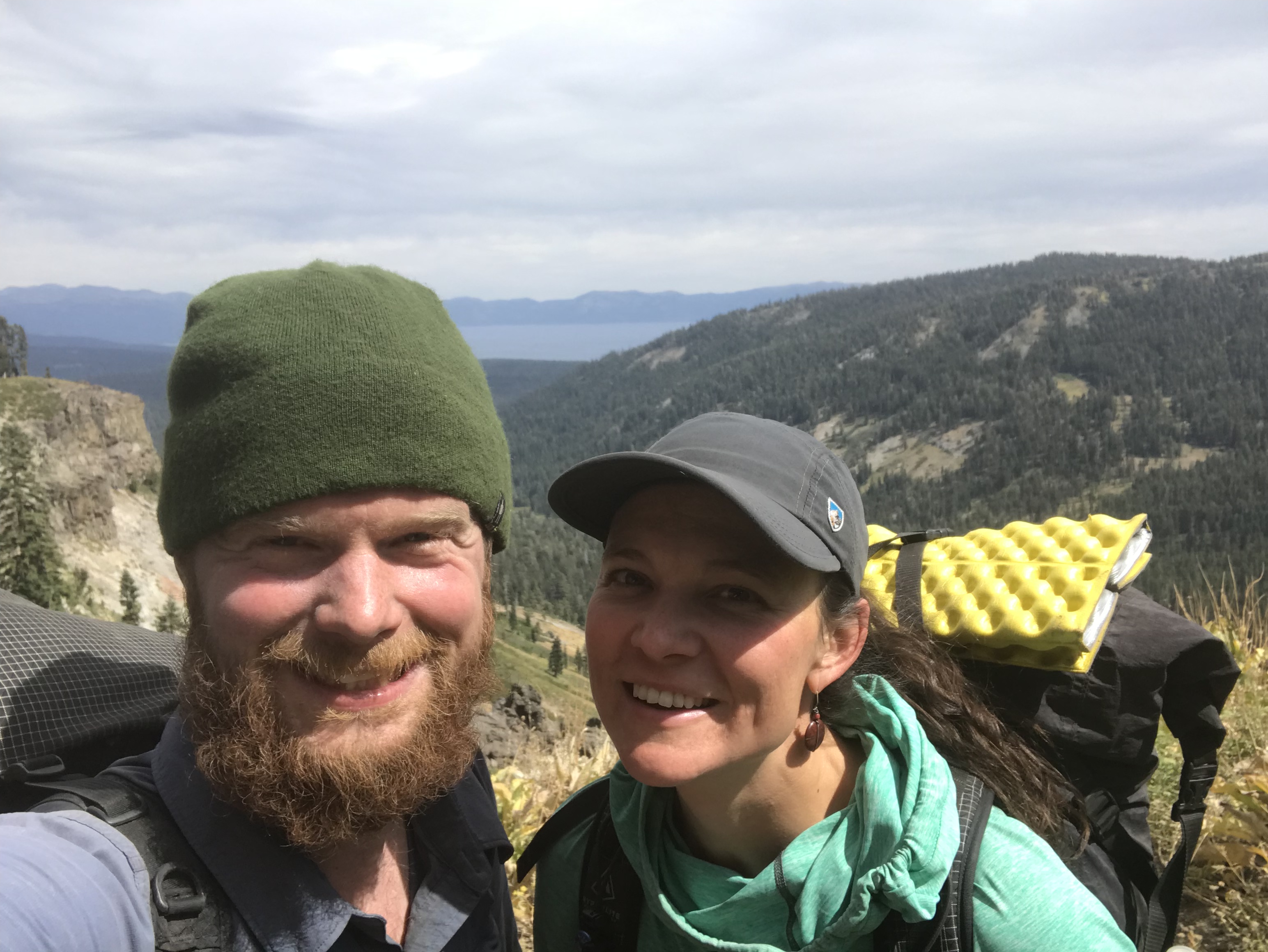
Jen is from Washington state between Seattle and the Canadian border. She grew up hiking in the North Cascades with her family. She went on her first backpacking trip at about 12 years old with her dad and brother. Jen is returning after seven years in Mexico City to the US to hike the Pacific Crest Trail. She’s looking forward to mountain meadows and Cheez-it crackers.
I’m giving a talk about our hike on April 7th at the REI in Bellingham, Wash. I will talk through the trip and discuss some of the logistics. If you’re in the area I would really love to have you there. It’s free. Here’s a link with details about registering: https://www.rei.com/events/95766/step-by-step-on-the-pacific-crest-trail/274200
It has given me such joy to read the responses to our posts since we started the trip. Thank you so much for following our trip! Thank you so much for your encouragement! It really meant a lot to us!
One day near the end of our hike, I decided to count my steps. Walking to Mexico isn’t always exciting stuff. Turns out counting your steps is even more tedious. I only made it 0.1 of a mile. In that distance, I walked about 250 steps. If you work that out, I took around 6.6 million steps to complete the PCT—around 50,000 steps on a standard hiking day.
The last few days of our hike to Mexico I didn’t need to count steps. They were glorious days—the kind of weather I thought we would have for the whole trail. We walked through a sun-streaked desert and past pristine lakes.
The desert has more green than you might expect.
Getting close to the end of the trail did not diminish the great effort it took to hike 25 miles a day. Just before the end, we decided to make a surprise detour to the Oak Shores Malt Shop, a corner store and restaurant, in Lake Morena, California. Making an unexpected stop like that felt as if we were playing hooky from school. We dashed off the trail just for a moment to have burgers and fries – they would be the last guiltfree burgers and fries of the trail. After the trail, we knew that greasy food would come with a price – extra pounds, an extra workout, an upset stomach.
We devoured our meal—like always, grabbed a six pack and returned to the trail with the glow of a town visit. We hiked up to the top of the rise where we could look out over Lake Morena. The sun was setting and I tried to take it all in—to remember those fleeting moments. Jake and I hiked on into the twilight and made camp at the bottom of a valley under the protection of oak trees. As always I fell asleep quickly—my body needing the recovery after a hard day’s work.
Coyote melon grows along the trail.
In the morning, I woke before dawn and heard the rustling of oak leaves above. They fluttered and brushed together like wind chimes. I closed my eyes and drank in that sound. There would not be any more mornings like that. It was the last day on the trail.
Our last day on trail felt like the first. Every step on a thruhike is like every step anywhere else. It doesn’t get any easier. If anything, it only gets more automatic.
We had planned to hike to the end. We hope to make it there by midday or early afternoon and catch a bus from the nearby town of Campo.
Three miles from the border
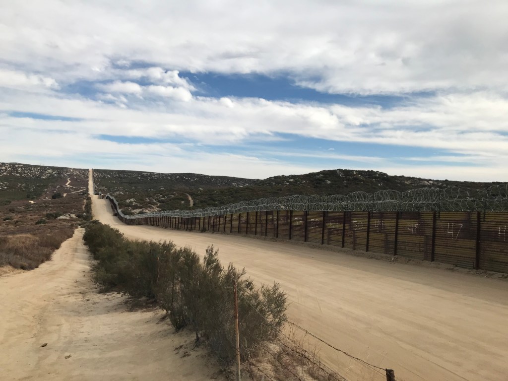
We climbed through sand and brush, over railroad tracks, we skirted the edge of the town. Finally, we came over the edge and we could see the border.
In the past few months, people often asked me different versions of the same question: “When did you know you would finish?”
I usually dodge the question.
My honest answer: I knew I would finish five steps from the end of the trail.
A dirt road follows the border
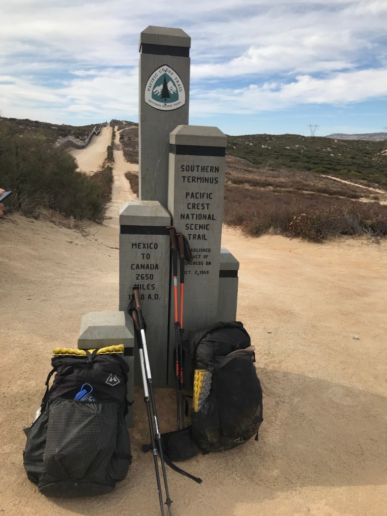
Just a bit before the Mexican border, the trail climbs a bit. The foliage falls away. There is a dirt road up to the terminus. While we hiked on the trail, an SUV and a car drove alongside us and made it to the border almost at the same time. As Jake and I hiked to the terminus, I was overwhelmed with emotion. Seeing that structure gave me a deep sense of gratitude for our great adventure and a sadness that it was now coming to an end. As I laid my hand on its posts, tears came to my eyes. I was overwhelmed the by force of 6.6 million steps.
The terminus
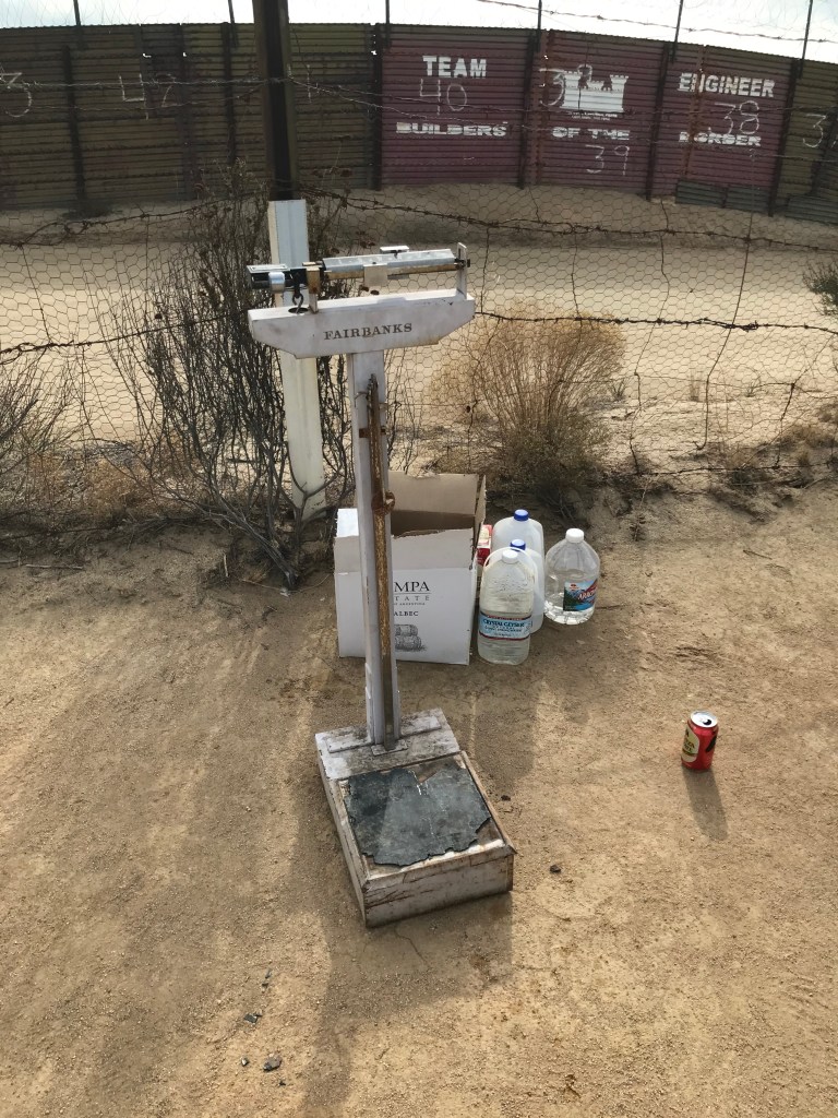
Among the detritus at the border, there was a rusty doctor’s scale with a chipped footpad and the brand name Fairbanks. Jake found a box of Tecate beer behind the scale and handed me a lukewarm can. It tasted like heaven.
I had only taken a few sips, when a group of people—tourists, I guess—piled out of the car that reached the border at the moment we did. They had all sorts of questions. It felt like we had somehow stumbled into a living history exhibit. It felt so surreal. At the same time, I was thrilled to talk about the trail. It felt like life had engineered an impromptu cheering squad for our finish line. That was only the beginning of the serendipity.
Wanna check your weight?
The driver of the SUV had just completed a section of the trail. She was heading to San Diego—our destination as well. Without a second thought, she offered us a ride. “Yes!” we responded enthusiastically. Then we gave each other knowing glances: the trail provides. We posed for a few photos, signed the register, took one last look at the monument and then we were off—back to the real world of cities and jobs and refrigerators and electricity.
When we finished the trail, a friend of mine messaged me that she was looking forward to the blog post summarizing it all. “We need some closure and reflection.” It has taken me over two months. Closure is hard to come by.
Every time anything feels overwhelming, I think about how we lived on trail: one step at a time. Sometimes there are missteps. Sometimes there are great strides. They are only steps. Not great blunders. Not great triumphs. Just steps. And I have to hope that a few of them are in the right direction. After all, we managed it for five months.
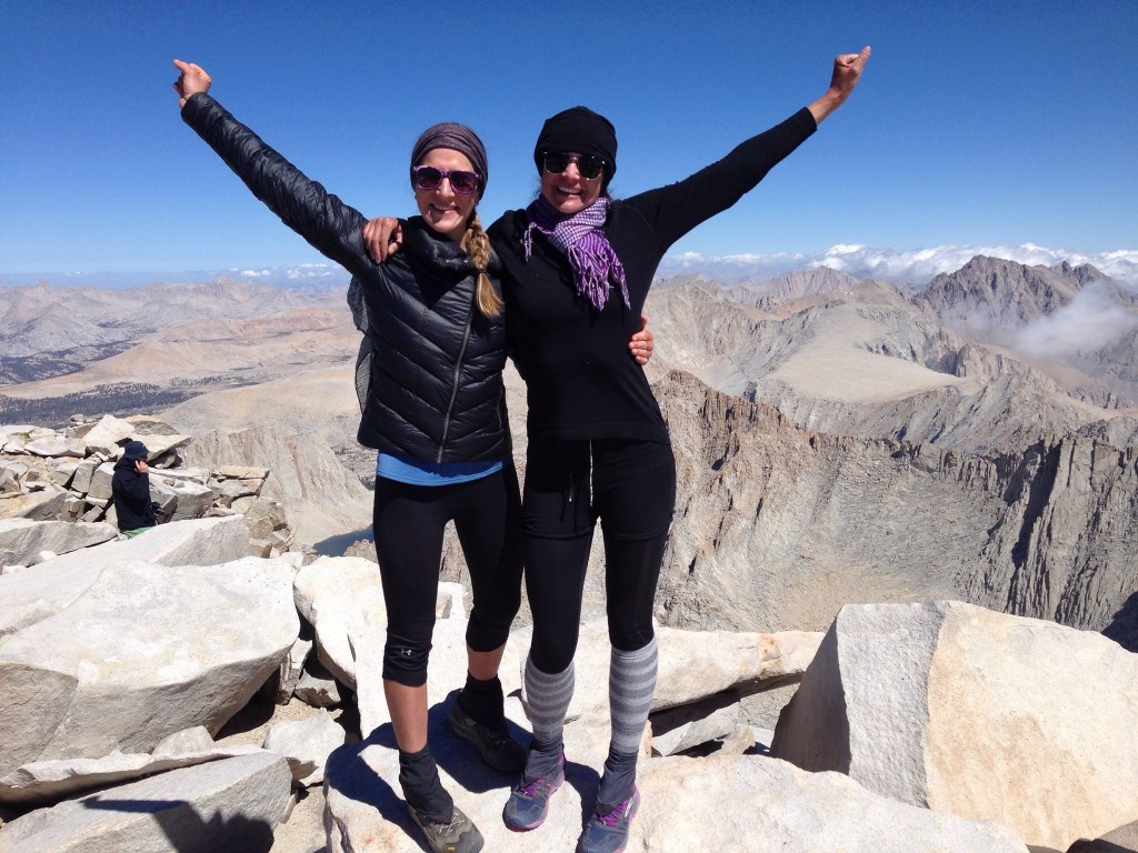
At the end of a 2,653.1 mile continuous footpath across the country
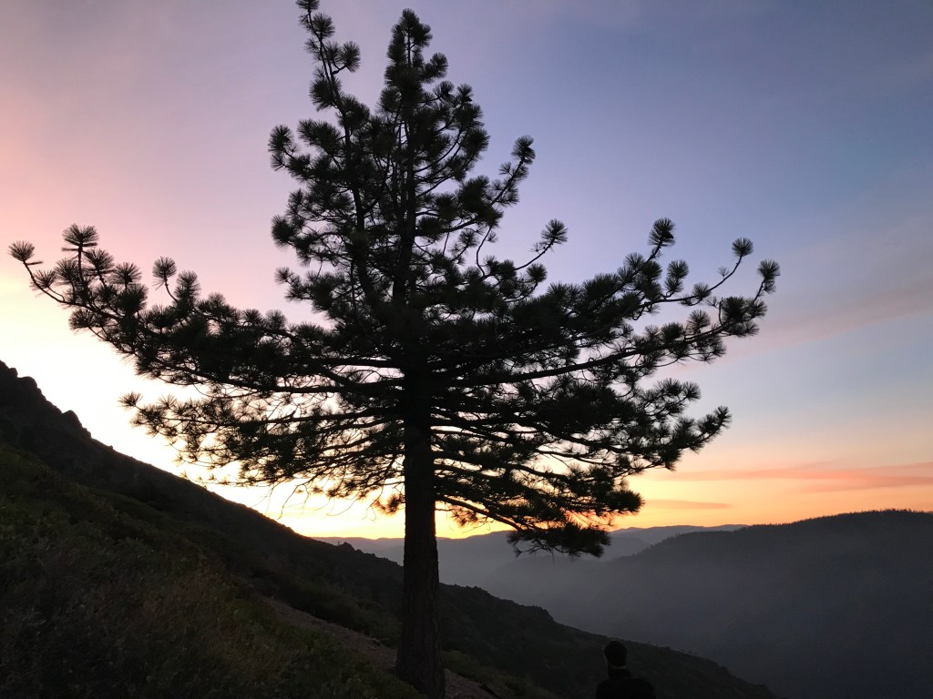
Hiking in half-light somewhere in Northern California
I never thought I would thruhike the PCT. I never thought we would finish. Even in our best moments, I was brought down by fear.
Four years ago, after completing the John Muir Trail, I said I would never thruhike a long trail. I was sick for most of that trail and re-injured an old sprain. That hike was an endurance test. I signed up for the PCT terrified that I would have to endure 2,653.1 miles of the same.
Finishing the John Muir Trail in 2015
Thruhikers have a saying: “You pack your fears.” Different people have different interpretations of the adage. I understand it to mean that you carry things in your backpack that you think will protect you from the things that you are afraid of.
I was afraid of everything.
I was afraid of the dark. I was afraid of bears and mountain lions. I was afraid of sprained ankles. I was afraid of mosquitoes and bees and beetles and every creepy crawly thing. I was afraid of carrying too many things in my pack. I was afraid of carrying too little. I could go on…
A funny thing happened on the way to Mexico. I got used to my own fear.
When we night-hiked, I was so nervous that a ferocious cougar would attack us from the shadows. And then one night I heard something rustle in the bushes. I flashed my headlamp toward the animal. I saw it dash away. I don’t know what it was, but it was BIG. I called Jake with a quivering voice. And Jake arrived. The “thing” stayed in the bushes. We didn’t die.
Castle Crags in Northern California
When my feet ached during zero days, I was so sure that our trip would be cut short by injury. Then we met a triple crowner in Packwood, Washington. He told us about his hikes on the PCT, the Appalachian Trail, and the Continental Divide Trail. Turns out he had a stress fracture and completed the PCT all the same. “You can hike with a stress fracture?” I asked him. “You can hike through anything,” he said. Somehow that conversation changed my attitude. Pain was part of the trail. Pain continues to be part of my life. It is something I’m managing. It isn’t killing me.
When bees buzzed us during the long hike, I always shooed them away. I was worried they would sting me. But one day in the desert, I came across a spring. There were bees everywhere, and I was alarmed. Then I looked a little closer. I saw the bees were drinking water! They were more focused on the water than on me. From then on, whenever bees came around, I let them buzz. I never got stung—not even once.
Glacier Peak Wilderness
What once was aversion became a general fascination with creepy crawly things. I loved seeing the giant Pinacate beetles that stick their butts into the air when they feel threatened. I loved finding red velvet ants with their fuzzy rust-colored bodies. Around a hundred miles from Mexico, we started to see tarantulas. They moved so gracefully. And they followed the trail just like we did.
California tarantula in the desert near Julian
I told one of the last trail angels we stayed with about my fascination with tarantulas.
“Why don’t you pick one up?” he asked.
“Maybe I will,” I said.
Even as I said it, I knew that it might be a step too far.
After all, I still have all of the same fears. I still don’t like hiking in the dark. I am still unnerved by aches and pains. I still worry about animals—big and small. But somewhere along the way, I decided that fear was part of life. I decided that my fear was just another thing I carry. That decision made my fear a little less of a burden. That perspective allowed me to finish the trail.
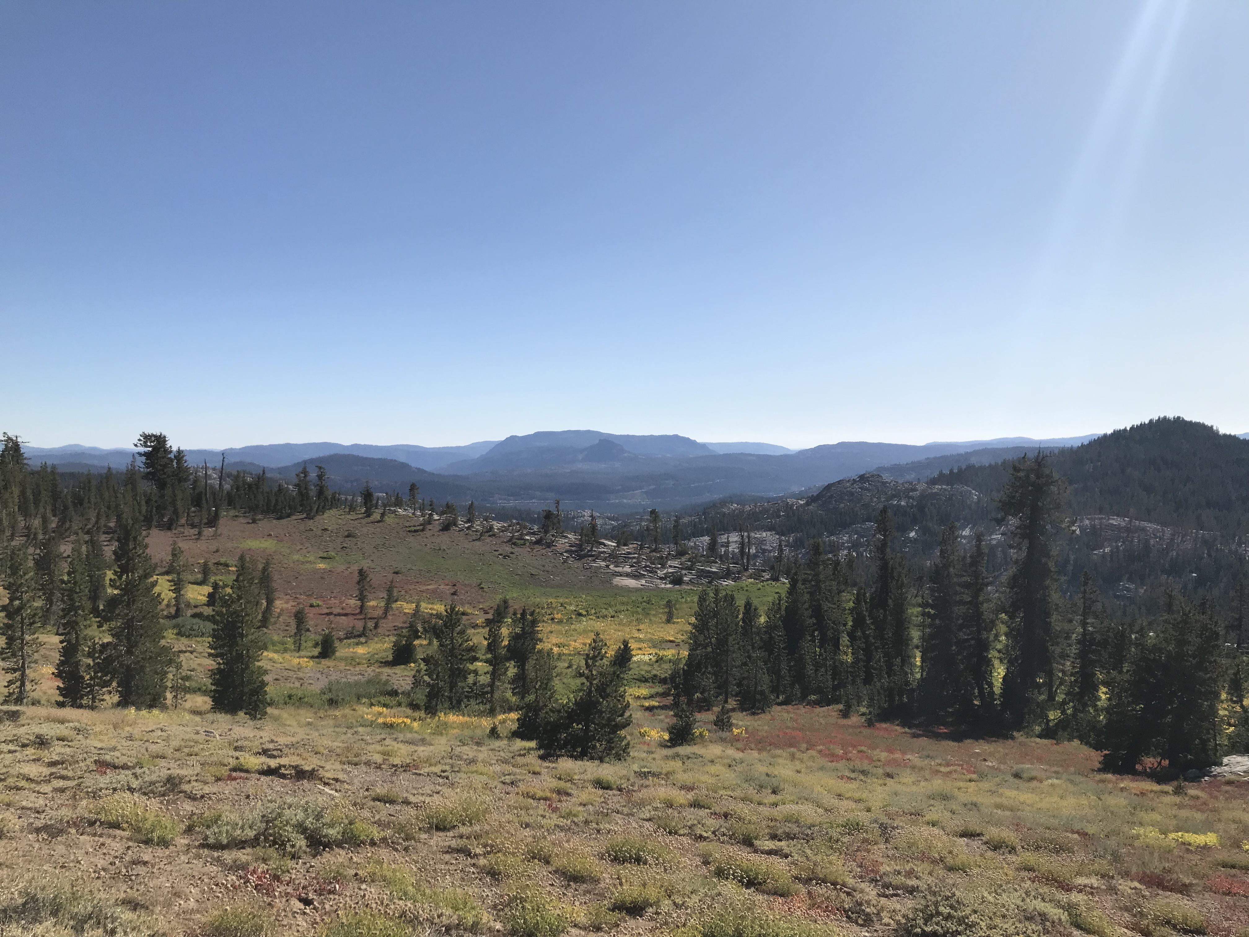
Green Valley is just as advertised. In late October, most valleys in California turn a sort of brownish yellow. But Green Valley remains.
We arrived in Green Valley around 1 pm and picked up some snacks at the convenience store. Just as we got there, a minivan pulled up.
“Hey hikers!”
It was Terrie Anderson, a woman well known in the PCT community for hosting hikers with her husband Joe.
Green Valley is a perennial favorite because of Anderson’s home known as Casa de Luna.
“There are two kinds of hikers,” Anderson said. “Those who stop at Casa de Luna. And those who wish they did.”
In 21 years, Casa de Luna has become the kind of place anyone on trail can call home. We were among those who stopped there, and we were lucky we did.
The day we visited Casa de Luna the Santa Ana winds kicked up with fiery force. Around mid-afternoon, a news alert caught our attention. A fire was burning out of control near Agua Dulce.
That was our very next stop. It was only 24 miles away — a day’s hike.
We checked in with friends on trail who were just ahead of us. They had made it to a spot about 10 miles ahead and saw smoke. Rather than risk hiking into the flames, they had to bailout at a road crossing and head to another town for a night in a hotel.
A rule adorning the wall at Casa de Luna
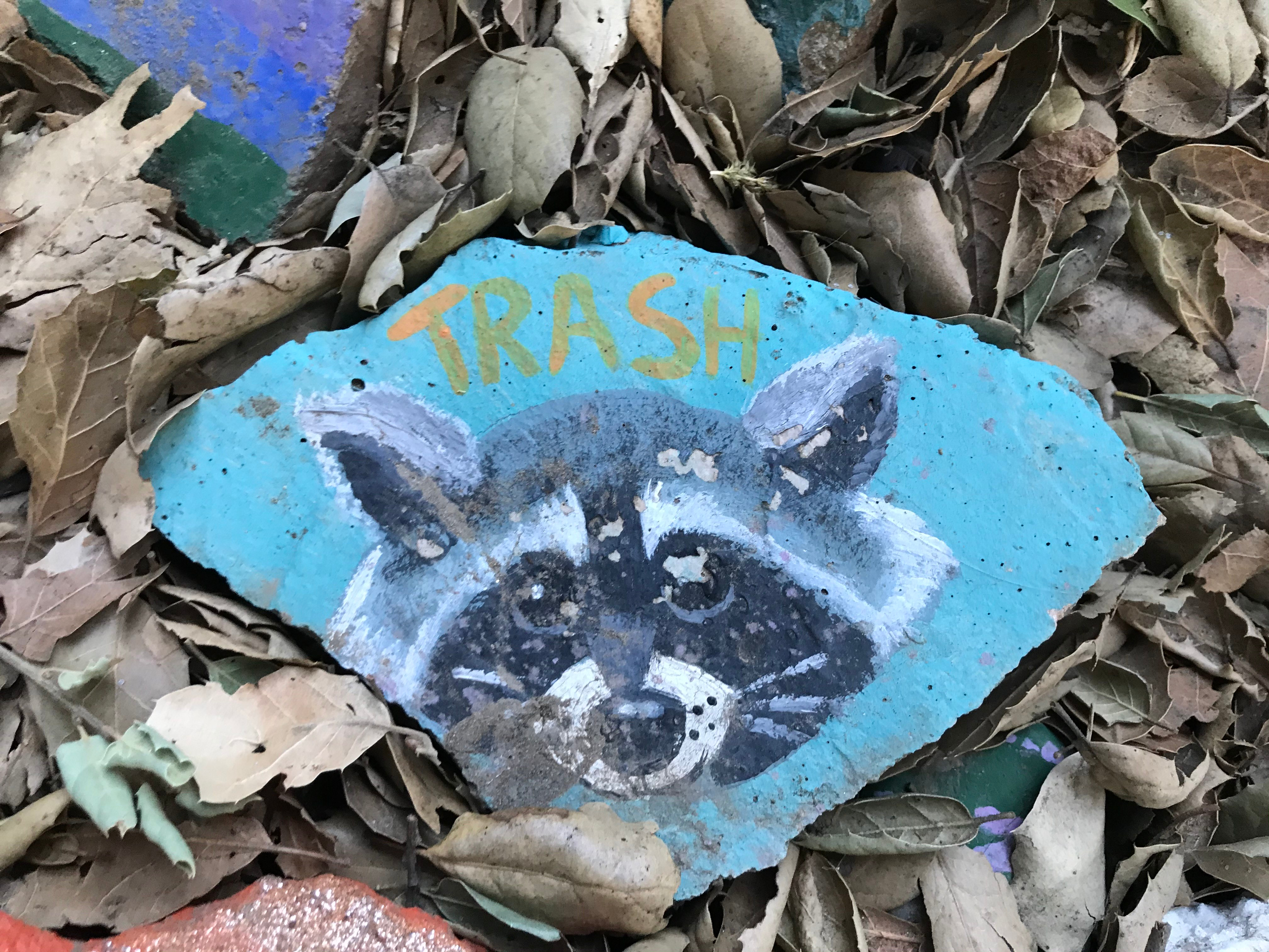
We asked Joe and Terrie if we could stay at Casa de Luna and assess the fire danger in the morning. They welcomed us without hesitation and told us about the “magical manzanita forest” in the backyard where we could set up the tent. Behind their house, we wove our way through a grove with tentsites carved out among the trees. All through the forest, we found rocks painted by hikers over the years. Some have apropos sayings: “Home is where you hang your food bag.” Some are eye-rollers. “Caution: This Rock is Hard,” wrote someone named 6-Pack in 2018. Some have hikers’ names such as Hiccupz, Xena or Mr. Peanut Butter. Others are oddly beautiful renderings of trees, waves, a starry sky, a hummingbird or a raccoon. It was hard to walk through the magical manzanita forest without getting distracted by a rock at least once.
One of the many rocks at Casa de Luna
I’ve read advice about getting to Casa de Luna early during the height of the PCT rush: “The good spots go quickly.” We found the perfect spot next to a plastic lawn flamingo perched on a manzanita branch. We were the only hikers that night.
Casa de Luna
We went back to Joe and Terrie’s front porch. We watched the evening news for updates on the fire. Joe and Terrie shared a taco dinner with us.
This was Casa de Luna’s last season in operation. The Andersons are moving to Washington to be nearer to grandkids. Terrie was already packing when we got there and posing questions like “how many socks does a person need?”
We joined Terrie for a couple of episodes of Family Feud before we retired to the manzanita grove for bed. The last thing I remember hearing was the yip of a coyote in the hills outside of town.
In the morning, Terrie invited us for coffee at the house. We took our seats on the porch and checked the news. Firefighters had made headway to contain the blaze, but it was still at a dangerous stage. It was not on the trail, but it was near it.
Jake and I know what it’s like to walk through smoke. We had already been through it near Mount Lassen in Northern California. One day we reveled in a glorious red and pink sunset, and the next we were shrouded in smoke from a fire miles away. Smoke is not like fog. Fog cleans out your lungs. Smoke sweeps into your lungs like a virus. At first it feels like nothing — just a tickle in your nose hairs. Then it pricks the back of your throat. Slowly, it builds to a hacking cough that chokes away your energy. At that stage, the smell is overwhelming — as if you had smothered your face in embers. Then a wind comes through in the night and sweeps it all away. In the morning, it’s clear without even a whiff of a campfire. Or at least that’s what happened near Lassen.
Smoke makes an eerie sunset near Mount Lassen, California.
In Agua Dulce, there was danger. It was not worth wandering into a forest fire. We asked Terrie if we could take a zero day in Green Valley. She agreed even before the words were out of our mouths.
In the afternoon, more hikers showed up — some walked up to the house. We ran into some people at the corner store and told them about the Andersons. Not that they needed to be told. Everyone knew about Casa de Luna. Joe and Terrie’s place felt like home. All were welcome. It didn’t matter how long they stayed. The Andersons told stories about hikers who had partied too much, made big messes, had too much fun — but never of anyone overstaying their welcome. When Joe and Terrie shared stories, they tumbled out all in a heap. Many trail angels say they host hikers to hear trail stories. But Joe and Terrie had trail stories and then some.
“I hear you used to mud wrestle hikers,” someone said.
“It was actually in oil,” Terrie responded.
And then we were off on another great adventure about trail pastimes and the old days.
“What’s it like in the summer?” someone inevitably asked.
“Oh, you wouldn’t recognize it,” Joe said.
“We have five porta-potties out front,” Terrie said. “People are everywhere. When it comes time for dinner, the line goes down the block.”
It was hard to imagine. Over the course of the evening, eight or nine hikers arrived. It felt nice to be in a group of so many people doing the same crazy thing as we were. It also felt a little overwhelming. Joe and Terrie told us they had nearly 90 at one time this year. It boggled the mind.
It must be hard for the Anderson to get to know the hikers in a herd like that. People come for dinner, they paint a rock, they take a photo and then they leave. But somehow, Terrie seemed to remember everyone’s trail name.
As the day dragged into evening, more news came in. Firefighters were making progress in Agua Dulce. The blaze wasn’t fully contained, but it was more controlled. The wind could still change directions, but we would have a day or so of protection to make it through Agua Dulce. Terrie called a trail angel who lived there. “They lost power,” that angel said. “But the fire is not a threat, and it was not near the trail.”
We decided to go to sleep and make an early start. The next day Terrie drove us back to the trail around 8 in the morning. She gave us big hugs and words of encouragement and sent us on our way. It made me smile as we labored up the hill out of Green Valley. We stayed to avoid the fire. I left feeling like my soul had been refreshed.
It was pouring the morning we were supposed to leave Mammoth Lakes and hike into the section with the highest passes on the Pacific Crest Trail.
We looked out the window — dark clouds hung in the sky. Rain cascaded off the eaves of the hotel.
I felt a mix of anticipation and anxiety. The forecast called for snow and freezing temperatures.
Why hike? I wondered. We could just stay in town and wait out the storm in a warm hotel room.
I put the thought out of my head. We got a ride out of Mammoth Lakes from an employee of the ski resort. He had worked at the resort for years and graciously agreed to drive us up to the trailhead. We stocked up in Mammoth Lakes on gear to help us get through.
We were leaving town with wind blowing in our faces. Clouds passed overhead. Rain or snow — something was coming our way. I felt as if we were racing it.
We hiked through a burn area that we remembered going on “forever” while hiking the John Muir Trail in 2015.
We hiked past a place I remember camping in 2015. On that trip we often made camp before nightfall. On the PCT, we’re lucky to make camp before dusk.
Just as night fell, we set up the tent near a creek. We looked for a sheltered spot, protected from the storm brewing overhead.
As we climbed into our sleeping bags, the first wispy snowflakes were just beginning to fall. Another couple of hikers had made a campfire. The flames cast an amber glow against the boulders. It looked warm, but my quilt seemed even more inviting.
In Mammoth Lakes, we bought Nalgene bottles for just such an occasion. We boiled water and poured it into the hard plastic bottles. Then we put the bottles in our sleeping quilt. They warmed up the quilts and the quilts kept the heat in.
Initially the snow was light. It wasn’t even sticking, but around 10 pm it began to collect. I woke up with a start to the sound of Jake hitting the sides of the tent with his hand. Snow was weighing the tent down. I helped, smacking the walls until sleepiness overtook me again.
We’ve been through so many storms, I thought to myself. No reason to worry yet.
With that, I cinched up my sleeping quilt and fell asleep.
In the morning, I was aware of the cold first: the wet, but not saturated, feeling of a snowy morning. My Nalgene was only lukewarm. I looked at the sides of the tent. There was only a little more snow than the night before. Outside only an inch or two had accumulated.
We heated the water from the Nalgenes for coffee and oatmeal. The lukewarm water warmed up faster than frozen water would have. But it still took time. We were in no rush. Fresh snow covered the trail, making it harder to find. It would be easier if other hikers went first. Then we could follow their footprints.
We had other chores to do anyway. I bundled up in my down jacket to walk down to the creek to collect water. Little snow drifts had collected around boulders at the tentsite. My shoes left distinctive prints in the fluff outside.
Thick ice lined the creek. I plunged the water bladders into the water and carried them back to the tent. Then I climbed into my sleeping quilt to filter. After squeezing the nearly freezing water bladder in order to filter the water into a bottle, I buried my hands in my quilt to warm them up again.
We shook the moisture from the outside of the tent as we packed up. As we folded and rolled, a brown square of dirt and pine needles was revealed where the tent had been — the only visible dirt in all directions.
Finally we loaded up our packs and got moving. As our footsteps met the trail, we saw the footprints of other hikers who had hit the trail earlier that morning.
Among them we saw another set of tracks. At first it seemed like someone was hiking barefoot. Then it dawned on us. They were bear prints. They looked fairly fresh. We looked around.
The snow made everything seem very quiet. There was no rustling in the bushes. There was no furry snout through the trees. There wasn’t even the cracking sound of a twig. There were only bear prints going the same direction we were. So we followed the trail. Every time I thought the bear prints had disappeared, they would reappear again. We never saw that bear. I know we are supposed to be afraid of them — those stronger beings with sharper teeth. But I took comfort in the thought that we were sharing the trail for at least a mile or two.
From time to time on trail, I have found a little green envelope on my backpack.
Inside there is a card with a message from Jake.
“Let’s go hiking!” says one.
Jake has been giving me these cards since we celebrated our two-year anniversary on trail.
As our mileage has increased, the cards’ messages reflect that intensity.
“Let’s do 34.2!” says another card.
They always make me smile. I have saved them in a ziplock bag.
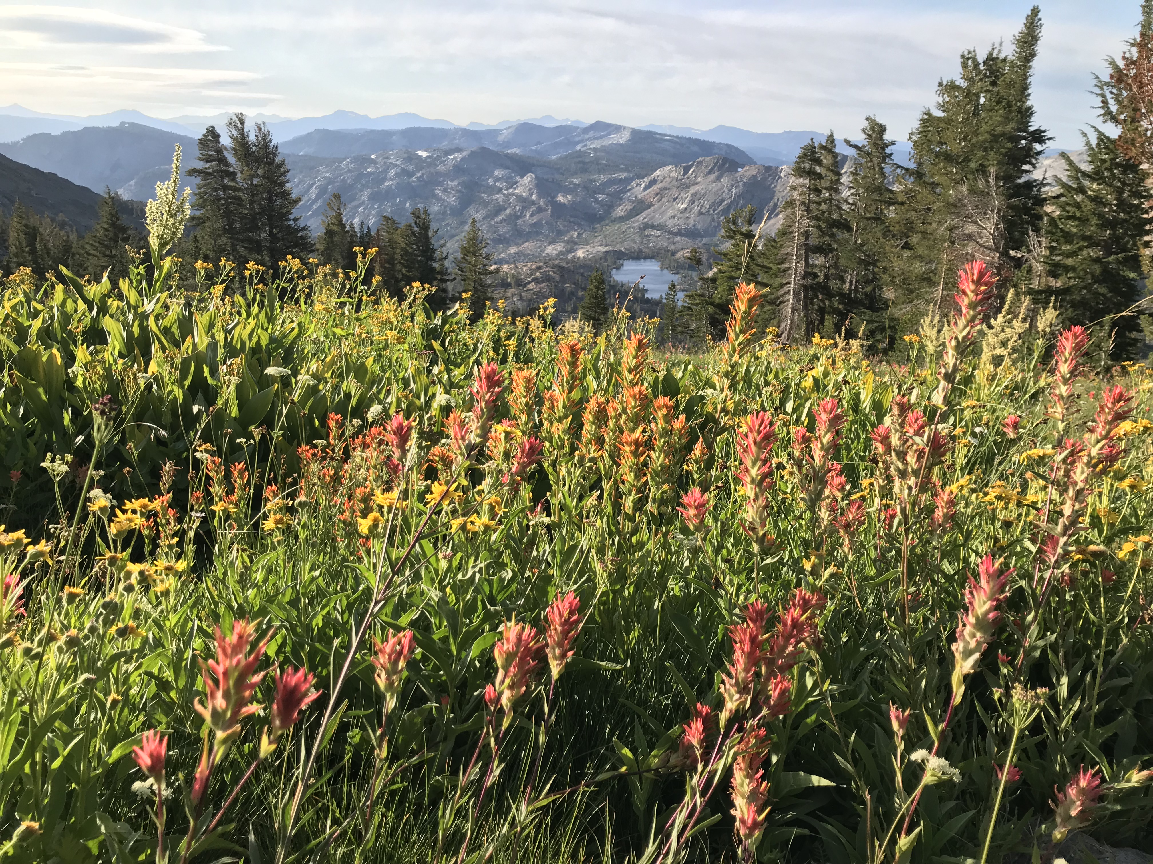
As we hiked into Tuolumne Meadows in late September, that bag was buried deep in my backpack, safe from the rain and freezing temperatures of the high Sierra Nevada mountains.
Walking into Tuolumne Meadows
Tuolumne was a significant milestone for us. We both hiked the John Muir Trail in the summer of 2015. That was before we met. We bonded over tales from that hike. It has always felt like an important part of our story.
As we hiked out of Tuolumne Meadows, Jake teased me that another card was coming by showing me the corner of a green envelope in his pocket. Throughout the morning and midday, we hiked the miles up to Donohue Pass.
After the pass, the trail turned from switchbacks through vertical, almost hanging gardens to a winding path through a lush convergence of creeks and streams. I remember that meadow from the JMT. It’s one of my favorite places in the world. But like all the best places it’s not easy to get to.
The last of flowers of the season
We still had another pass to climb before camp.
As we came over its rise, we saw an expansive lake dotted with islands. The still water reflected the pink light of sunset behind Banner Peak, which was still dotted with snow from the winter. I had stopped at Thousand Island Lake on the JMT in 2015. Jake had camped there that year. He was looking forward to camping there this time.
Thousand Island Lake
We hiked a few hundred feet off the PCT to find a tentsite. Jake found an amazing spot on a spit of land by the water. The sun was just setting as he staked out the tent. I fired up our stove and started boiling water to heat up a packet of Punjabi potatoes — one of a few dinner items left at Tuolumne Meadows Store.
The sunset
The water hadn’t yet boiled when Jake walked a couple of steps toward the lake and said, “Come over here. Look at the sunset.”
“It’s OK,” I said, focused on dinner. “I can see it from here.”
“No really,” he said. “It’s better over here.”
I figured I should probably check out whatever was over there.
I got to my aching feet and walked the few steps over to him. He had the green envelope in hand.
“The card!” I said.
I opened it.
And then he got down on one knee.
I was stunned: The sunset, the lake, the ring.
I looked at Jake and our whole relationship flashed before my eyes — meeting in Mexico City, our first hike, that time my apartment flooded and Jake came over to help, and so many other memories.
The feeling overwhelmed me and I started crying and hugged Jake.
“You have a drip on the end of your nose,” he said, laughing.
And there we were laughing and crying, snot-covered and engaged.
Jake captured this moment in the winter wonderland heading down from the trailhead to South Lake Tahoe
“There’s a red flag warning,” Jake was checking the weather and speaking in the measured tone of a person who is definitely not freaking out.
We were already 23 miles into the day. And 68 miles from the trailhead closest to South Lake Tahoe.
“What?” I said. I had checked the weather earlier in the week and saw that it might rain, but a red flag means a storm.
“Wind gusts of 75 miles per hour… damaging winds,” Jake went on reading. “Snow showers… accumulation of three to five inches.”
It seemed impossible. The late summer sun had warmed us all day. The sky was a delicious blueberry.
Sun before the storm
We checked other sources. We checked other locations. They looked worse.
We exchanged glances. We expected storms. Jake and I hiked through the Sierra Nevada on the John Muir Trail in 2015 before we knew each other. We expected storms but not for another week or two. Plus we had been booking it for three weeks just to get to that spot. We had been keeping up with hikers far faster and far stronger. We were tired and ready for a day off.
We quickly agreed we would hike as far as we could that day and the next day.
A few hours later, we sat at picnic tables at Donner Pass, named for another set of ill fated travelers. We made dinner there and discussed our options. We searched online for what high wind feels like. Somewhere around 45 mph walking becomes difficult; around 60-70 mph trees can be uprooted. We found a bailout point “if things get really bad” about 28 miles ahead. Then we hiked on, hoping for the best. It was midnight when we laid out our sleeping quilts to cowboy camp under a nearly full moon and howling wind. We had hiked our longest day at nearly 37 miles.
Jake woke me at 6 in the morning as pink crept into the horizon. It was time to get up. The wind was already picking up over Tinker Knob. Another ridge beyond found us bracing against our trekking poles.
Windy but sunny
By the time we reached the “bailout point” that afternoon, the wind had died down a bit. Some friends caught up to us. They were discussing the possibility of hiking all night to avoid the storm. At this time we were in blazing sunshine. A sign declared 32 miles to the trailhead. We could do that mileage in a day easily but not after already hiking 20 miles.
Jake and I decided to press on for a few more hours. We would hike until 9 pm, set up our tent, sleep until 4 am, and hope that the storm hit an hour or two later than forecast.
We cooked dinner with the last of our fuel that night and set up in the most protected section of forest we could find. At one point, in the middle of the night I opened my eyes and saw that outside the tent, the trees were swaying in all directions. I closed up the tent and awoke before my alarm at 3:50. I began stretching my legs for the trail ahead.
We were up and out quickly. Hiking in the dark, we made our way toward Dicks Pass at 9,376 feet. The wind picked up. It threatened to knock us over at points.
Storm clouds gather
Off in the distance, I saw a bank of clouds galloping toward us. For the rest of the day, “Riders on the Storm” cycled through my head like a dirge. At the top of the pass, we ran into the first couple of hikers we saw that day and there was enough cell signal to check our fantasy premier league teams and text family.
On the way down, we stopped for peanut butter and jelly tortillas. I don’t even like PB&J. At this point on the trail, I eat anything. The break spot was sheltered from the wind and even sunny. We ran into a couple of hikers we hadn’t seen since Oregon. It was a strange reunion in the midst of impending doom. The sun gave us a false sense of security.
Hiking on, we ran into more people on long weekend excursions. We hiked past glorious lakes lined by fireweed and paintbrush. The wind whipped our cheeks and clouds gathered. Just after Lake Aloha, hail began to fall. Then it became rain, then sleet, then snow. We were still two hours from the trailhead… two hours ahead in wet snow. Faster than I’ve ever experienced, the snow began to stick. The temperature was dropping. It coated granite and turned dirt trail into a river. I began to panic. I couldn’t get warm. My beanie and down jacket were in my pack. I wasn’t thinking straight.
Jake stopped me to put on more layers and we resumed the climb. We slipped over rocks and hoped we could make it to the trailhead before our resolve dissolved. We skidded past other hikers. We slid in ever accumulating snow, seeking out the trail as it disappeared before our eyes.
Finally we made it to the trailhead. Looking for a hitch, we saw a section hiker getting into a Jeep. Jake dashed over to ask for a ride. The driver warned us that his Jeep was a convertible but we were just happy to be on the move. Less than an hour later we were washing the dirt off our feet and planning our town meals.
In the end we hiked 90 miles in two and a half days. We got to town tired, soaked and hungry but glad to be dry.
It was drizzling as we came up the hill, but we felt buoyant. We were heading into Ashland, Oregon for our first day off in 11 days.
And then we saw him: a dog.
Looking lost
At first glance, we couldn’t tell if he was friendly or grumpy.
His head was lowered and he was standing in the middle of the trail. Either he was lost or blocking the way.
I held out my hand to give him a sniff.
He obliged and then I scratched behind his ear.
He greeted Jake, as well, looking forlorn.
He had the coat of a mutt but a collar told us he must have a home.
We looked around. Although that section of the trail was close to Interstate 5, we couldn’t see any houses nearby.
“Hello? Has anyone lost a dog?”
No one replied.
“Do you think he’s thirsty?” Jake asked.
We had filled up on too much water at a spring 12 miles back.
I grabbed my titanium dinner cup from the back pocket of my backpack, and Jake filled it with water. The dog sniffed the cup. He didn’t need water.
“Too bad we don’t have any food!” I said.
The dog wasn’t skinny but had the look of a someone looking for a snack.
Unfortunately, we had nothing left.
I had eaten my last Snickers bar (not really suitable dog food anyway) a couple of hours before. Jake has shared some of his last Snickers with me at lunch. All that we had in our food bags were empty ziplocks and trash.
It was about 4 pm. We were in the last miles of a 25-mile day. We were heading toward a side trail that would take us to a lodge and restaurant and freeway to Ashland.
So we walked on. The dog took a few steps in our direction. We hiked on and he ran to catch up.
Oh, well, I thought, we have a new friend.
Every so often, he stopped to mark territory, giving the impression he was familiar with the territory. Sometimes he even walked in front of us as if he were showing us the way.
Leading me down the trail
We rounded the corner onto the side trail down the lodge and the freeway that would take us to Ashland. I was sure he would head back then. I looked back. He paused but continued following us.
The side trail sloped down steeply. At one point I felt a weight fall against my leg.
“Oh! He fell down!” I cried.
The dog’s legs had given out on the steep terrain and he had slid into my leg and trekking poles.
I started to worry. What are we going to do if we can’t find his owner? Big sections of the trail have bans on dogs. We knew a hiker who had a service dog, but that took paperwork and lots to training. I ran a few scenarios through my mind — none of them favorable. Then I put it out of my mind. “The trail provides.” The refrain I’ve heard so often since we started this hike flashed through my mind. A solution will present itself, I thought. I just don’t know what it is yet.
Within seconds, the dog was back on his feet again. We crossed a set of railroad tracks and had to redouble our steps as we momentarily followed the wrong trail. Through it all, man’s best bud trotted along behind us. I wondered if he, too, was imagining a new direction — abandoning his home for a life on the road with two homeless travelers. And then I remembered: he was a canine. He probably just thought we were going to feed him.
Crossing the railroad tracks
Finally we reached the road, which was really the off ramp of the I-5. We crossed it in the rain. And only here, the dog hesitated. There weren’t any cars but he seemed afraid of the road.
Eventually he mustered up the courage. And it was at that point I heard a car’s breaks.
I stopped in fear for this dog we had met only 30 minutes before. He had followed us. I felt responsible for him.
I whipped around.
The dog was ok. The car’s driver was leaning out the window.
“Bennie!” shouted the driver. “What are you doing down here?”
The dog turned toward him.
The driver knows him!
I walked back toward the white SUV.
“Are you his owner?” I asked.
“I’m the neighbor of his owner,” the driver told me.
“We found him up on the PCT,” I told the driver. “He followed us down.”
“Their property is near there,” the man said, already helping the dog into the backseat of his car next to his small child in a car seat.
It all happened so fast. The dog was found fortuitously — right as we were heading to the lodge and road that would take us to Ashland.
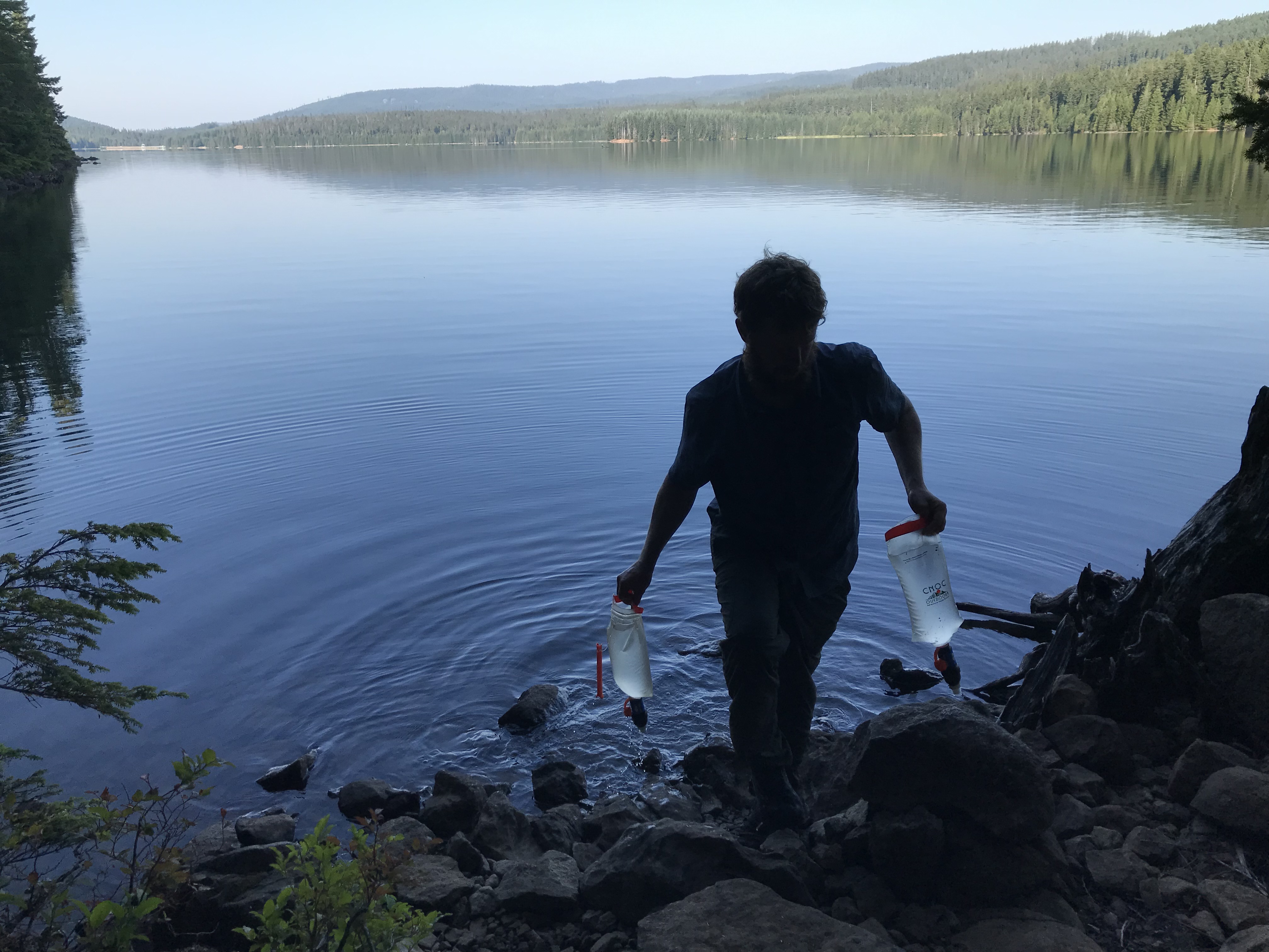
We were hiking around picturesque Timothy Lake in Oregon at about 8 in the morning. It’s normal to see smoke at night but not in the early morning, especially not on warm mornings like that one.
We were about an hour into what we hoped would be a 31-mile day, our longest yet on trail.
Through the trees, we could see a campsite but no tents. Jake went to investigate. A few seconds later, I heard, “The fire is still burning here! Bring your water bottle!”
After a month of cold in Washington, the weather is starting to feel like summer in Oregon. Hot oatmeal and coffee are unnecessary. We now breakfast on granola bars and cold lemonade. We’re using more sunscreen and breaking out our rain gear less often.
Naturally, the dry weather has us on alert for the possibility of forest fires, which in previous years have closed sections of the PCT.
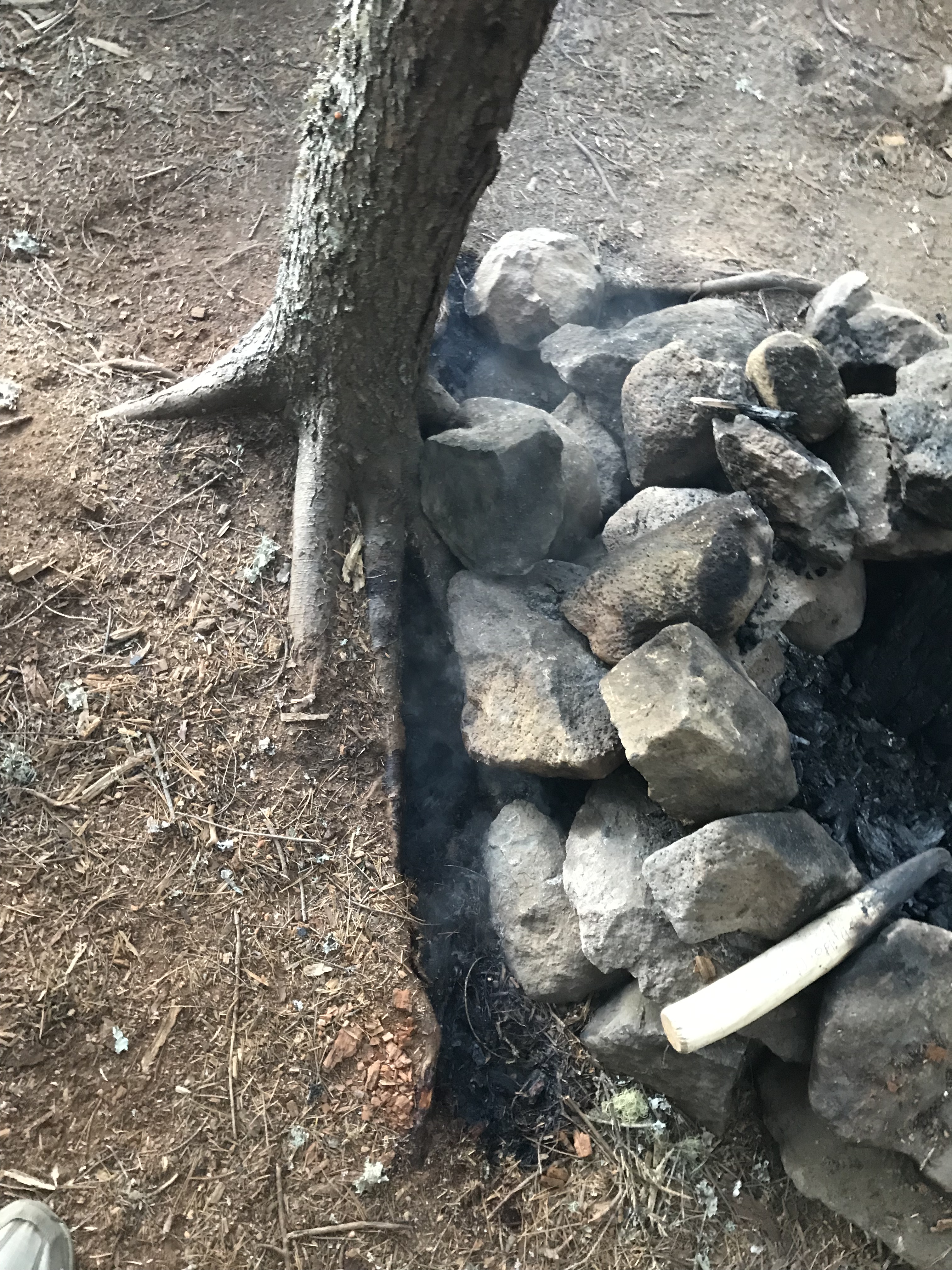
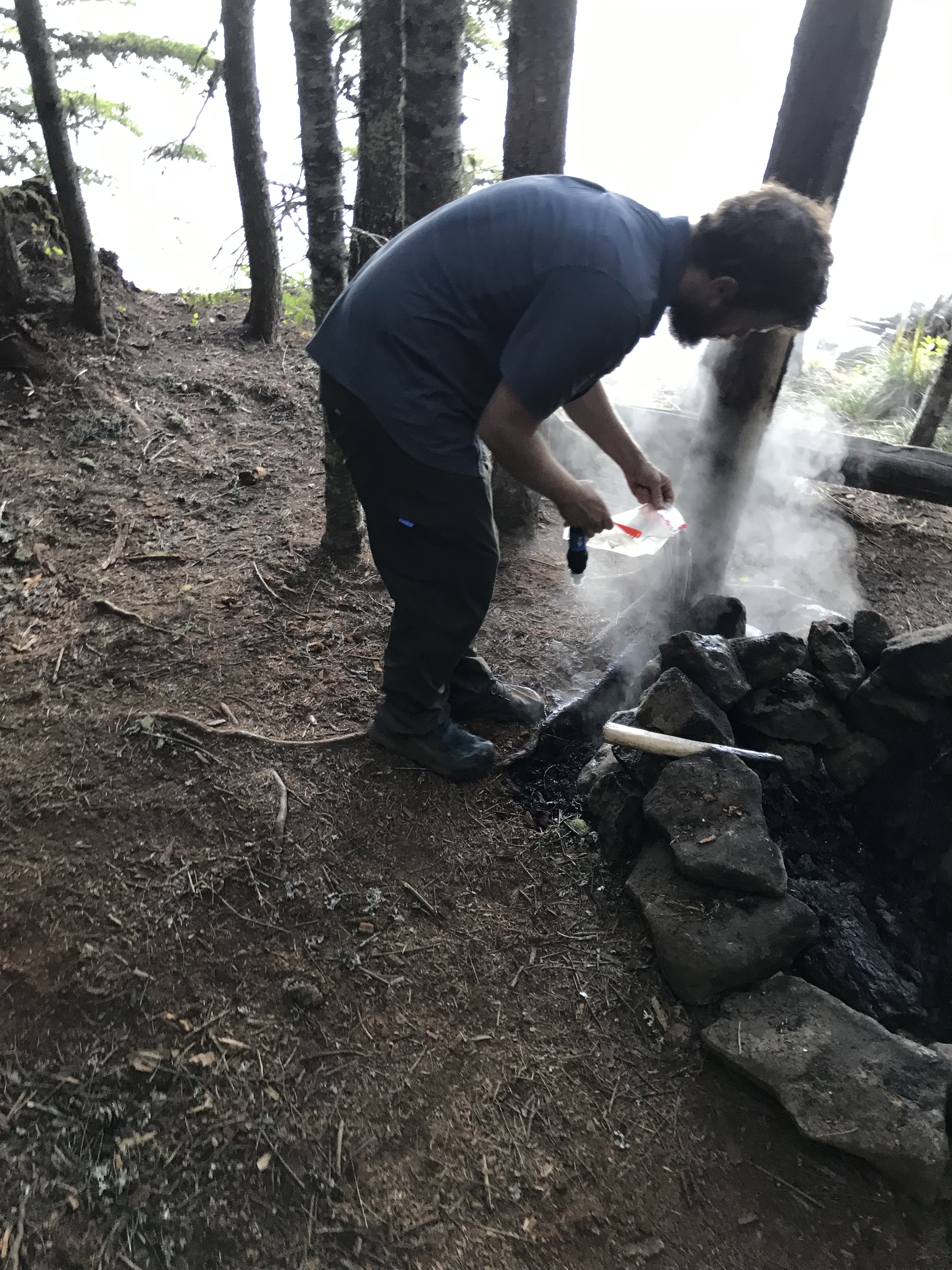
So when Jake told me there was a fire, I rushed over to help him. He was already drawing water from the lake to pour over a smoking section of soil. A poorly extinguished campfire had somehow burned underneath its fire ring and was smoldering along a scar outside the ring. Jake poured a few liters on the scar, and copious steam erupted. The fire went deep.
The smoking scar
I found a stick and started scratching into the dirt to find out what was burning. The fire ring had clearly hosted a huge fire. Large chunks of wood remained inside the ring. They blackened as if campers had poured water on them. The campers were nowhere to be found.
As I scratched at the ground I found still burning embers. The fire had migrated into the roots of a nearby tree. The more water we poured on it, the more it steamed. Because the fire was underneath the tree, it was tough to douse it with water, so I kept digging, trying to expose whatever was still burning.
Eventually, we started separating rocks in the fire ring as well to expose anything still burning below the rocks. Many of the volcanic rocks were still very hot to the touch. They smelled like a sauna and erupted with steam as Jake poured water to cool them down.
Steam coming off the burning roots of the tree
It took us about an hour and somewhere around 50 liters of water, but finally the fire seemed to be out. Tired and dirty, we resolved to hike on.
Just to be safe, I called 911 with the bar or so of cell service on my phone and was put through to the local wildfire dispatch. I was cautious about alarming them or diverting resources for something that was probably not an issue anymore. I told them that, while it wasn’t urgent, it would be good for someone to check on the campsite in a day or so to make sure the fire remained out.
A fireman from the area updated me by text later that day. They had found the spot and the fire appeared to be successfully put out.
It was tough hiking after all that, but the trail was kind to us and seemed to level out. We made it the 31 miles to our campsite, and set up our tent just before dark.
We we standing in the dark, staring down a dilemma. We had just hiked five miles in the dark to get to a campsite. The campsite was full. The next site was five miles on. The previous site was five miles back. Nowhere to go. Nowhere to camp.
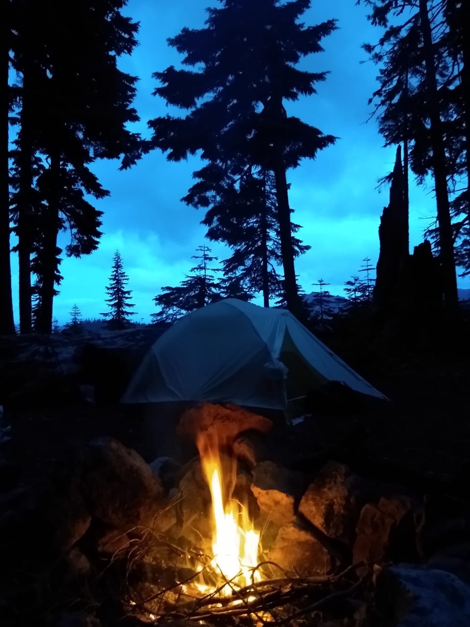
A rare night with a campfire
Before the PCT, this would have been an impossible situation. Five weeks on trail have redefined my sense of what’s possible.
In outdoor activities, there’s a sense of personal space that I will call “hiker space” in this post. Hiker space defines how far you pitch your tent from another hiker you don’t know. It defines with whom you eat your dinner and with whom you hike. Before this trail, if I had a choice, I would set up my tent as far away from other campers as possible. I would eat dinner with people whose names I knew. I would walk with hiking partners. It’s only polite.
We’re hiking the PCT. The rules of etiquette are different. On this trip, my sense of hiker space has morphed and changed more than I expected.
It started the first night on trail.
That night, Jake and I camped at a spot 11 miles from Harts Pass. Two guys were already there, awkwardly chatting and eating dinner at a campfire pit.
We arrived and set up our tent within view of the trail and within spitting distance of the other tents. We took a spot at the campfire pit, started making dinner and joined the conversation.
Twenty minutes later, another guy showed up. He joined the circle after setting up his tent at the last visible tentsite.
Tentsites are flat spots with space for one tent. They are cleared of debris. They’re in greater demand than you might expect along this trail. In any given space in the forest, you might find trees, flowers, downed logs, ferns and other undergrowth. Making a tentsite involves clearing downed trees, branches, and other debris. In most places along the trail, you’re not allowed to camp anywhere near the trail. Even if allowed, it takes a lot of energy to make a tentsite and it can damage the fragile ecosystem. In other words, it’s mostly out of the question.
With the addition of the last hiker. We thought the campsite was full. We were wrong.
All through dinner, more hikers showed up. Some kept hiking, but many squeezed in. They found spaces between tents. They found tentsites we hadn’t noticed. One group of four somehow found space off in the woods somewhere.
The five of us around the campfire pit stared in awe.
During a momentary lull in the conversation, one guy turned to the four of us and said, “This is the biggest social gathering I’ve been to in the last six months.”
At least I wasn’t the only one feeling awkward about the amount of people on trail!
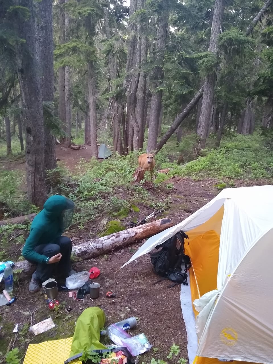
A visitor to our campsite
…
Last week, when Jake and I showed up after night hiking to a full campsite, we knew it wasn’t full. We found a spot next to the trail across from a tent with a snorer. Hoping the snoring camper would be least likely to be disturbed, we set up our tent as quietly as possible.
And it worked! The snorer droned right through. When we left in the morning, the snorer, who turned out to be a fellow PCT hiker, was just waking up.
“I didn’t even hear you get in,” he said.
We breathed a sigh of relief. Hiker space, such that it is, had been maintained.
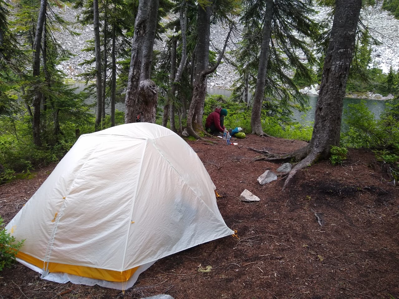
Cooking dinner at a campsite south of Stevens Pass


 It was pouring the morning we were supposed to leave Mammoth Lakes and hike into the section with the highest passes on the Pacific Crest Trail.