We said we should hike the PCT in the Black Horse English pub in Mexico City in 2017 on our first date.
We didn’t know each other in 2015, but we had both hiked the John Muir Trail at almost the same time. Jen had gone SOBO and I’d gone NOBO. We missed each other by a day or so at Whitney and would have stopped for a chat as you do but we met a couple years later. We both lived in Mexico City.
Now we live in the woods.
Reaching the border had been far from easy. Jen’s parents very helpfully drove us to Hart’s Pass through the mountains of northern Washington which rival the Alps. This is where most SOBOs (or southbounders) start from, having to walk north first to tag the border.
They dropped us at Hart’s Pass and gave a hitch back to Mazama to Broken Toe just as he finished his annual section hike to the border and back. He was going to collect his van to set up trail magic at Hart’s.
We, however, first had 31 miles over snow (or so we thought) to the border and then we had to return the same 31 miles, starting our PCT SOBO thru hike on the border. But the views here are so stunning the repeat does not matter. We’re underway now. 10 miles to a campsite today and about 13 tomorrow. Apparently it might rain. Almost glad I misread the forecast, this is a surprise.

(It’s now 1:40am and the rain is pounding down onto our frankly tiny leaky tent.)
We’re 6.6 miles from the Canadian border which we made it to exactly 12 hours ago. I fell asleep at about 8pm and now I’m wide awake listening to the rain outside. Hikers are rarely up much beyond 9pm but my sleep cycles doesn’t really match up at the moment. We hiked in glorious sun with vistas yesterday and the following morning but now the rain is here.
Getting to the Canadian border means we’re now officially southbound thru hikers on the PCT. Previous to that moment we had been northbound section hikers. A strange experience compared to other hikes because you get to see those hikers a day or two ahead of you and behind you. This year is also busier than usual. I’ll get to that later.
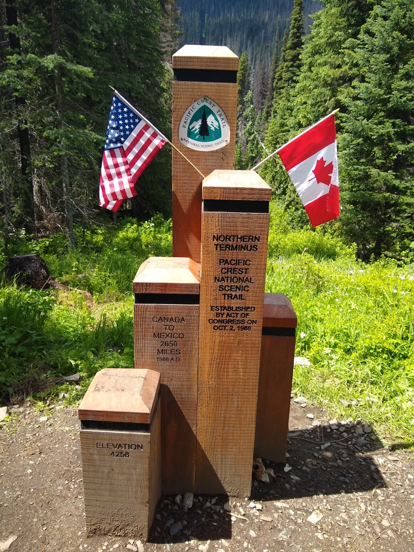
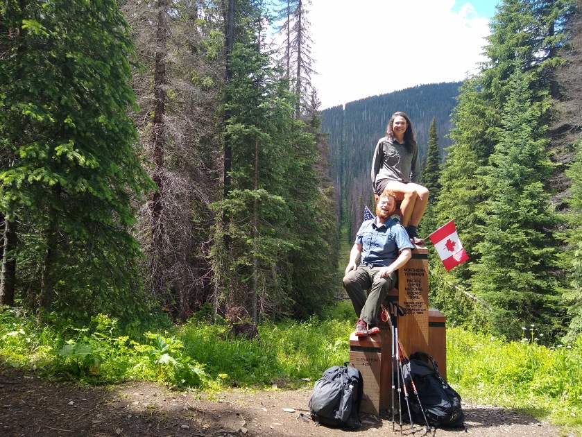
The border monument was glorious and unexpected, blasted by the sun coming down into the 10 yard wide border, sliced through the pine forest the length of the Canadian border. This is a place mainly signalling the end of a NOBO’s 2650 mile hike and the start of Canadian land. For us it meant the beginning of the 2650 mile journey to Mexico, our country of residence till just three weeks ago.
We left late after drying everything following a big downpour the night before and slackpacked (just taking the necessary for the day) down to the border by 1pm.
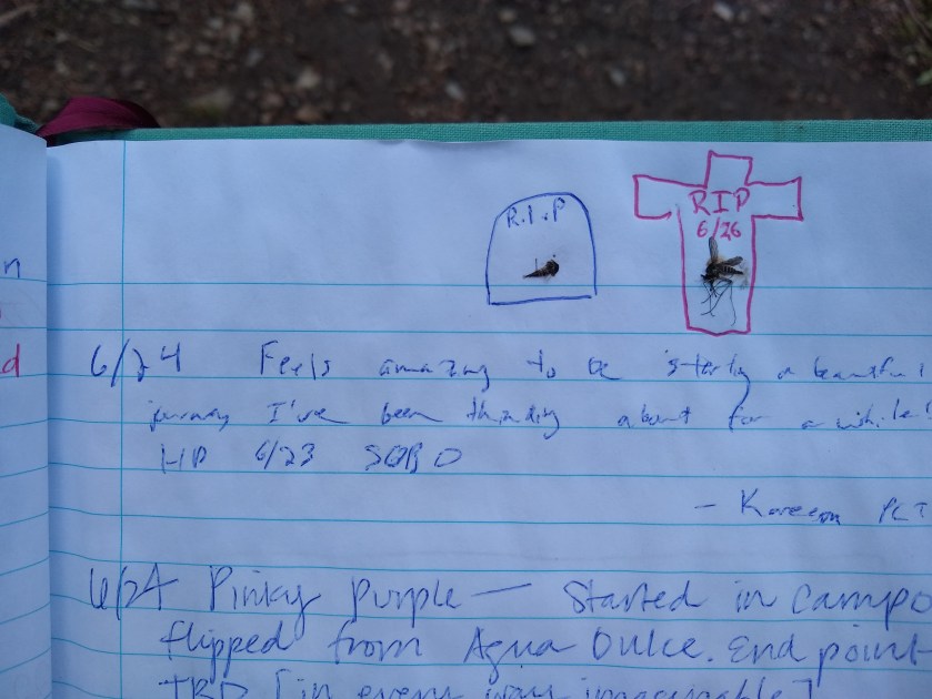
We had the place to ourselves for about twenty minutes and posed for pictures and executed poorly positioned timer shots of both of us pretending we didn’t have about four mosquitoes on each leg. We signed the monument book to register our tagging of the border. Hadn’t really considered what I would say so I said something factual about where I was headed and added a second mosquito to a future trend in that book then we hiked off back to Hopkin’s Lake to camp, contemplating the gargantuan trail ahead of us. An experience that will no doubt shape us in some way. At least in terms of stomach size and calf tone.
Later the next day we stopped to set up the tent to avoid a heavy downpour 8 miles after Hopkin’s Lake and I’m glad we did because it hasn’t stopped raining now for ten hours. Jen’s blog post above beautifully describes all the gory details. Happy not to be walking in it like most surely did as it started at 2pm and camp sites are sparce in these steep hills.

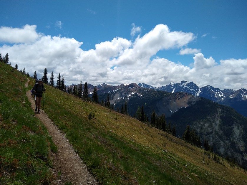
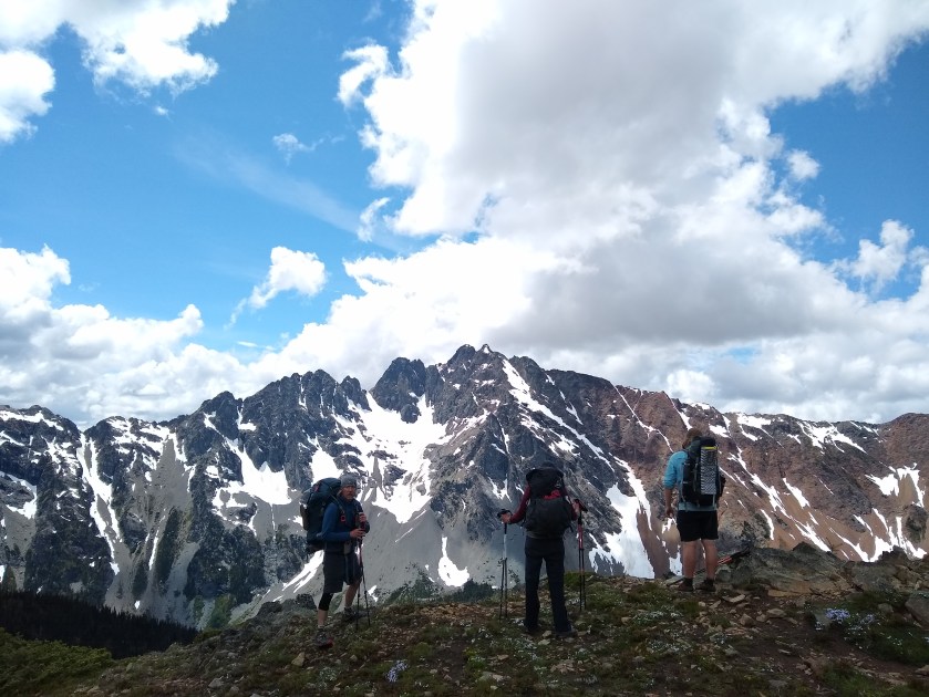
With or without rain though, the land here is nothing short of awesome, in the dictionary sense. Huge crags, lined with snow tower above us at low elevations and we walk alongside them after conquering the switchbacks. Each turn gives you a unique view of the same stunning backdrop of Washington’s peaks. We hike over snow patches, some sketchy though most carefree. I only used my microspikes in one section when it was slushy and was giving way steep above a boulder with my name on it.
Away from the small snow crossings, most sections have steady with long ascents and descents that are a joy to walk on. The PCT is pack animal grade which is luxury for hiking and even in the most challenging sections you can more or less accurately predict when you’ll get somewhere.

Hiking this amazing trail alongside us are a lot of flip floppers. These were northbound thru hikers who didn’t want to go through the Sierra in the insane snow. I’ve heard crazy stories from Sunny and others about the climb up Forrester Pass and so I’m not surprised they changed their hiking plans. Others flipped to Oregon, to northern California, took time to go to San Francisco and then go sobo. This year is a bit of a crazy one I guess. Hikers are spread out all over the trail which should lead to the meeting of many more hikers, hearing of many more tales and reunited hiker parties. 2019, the most integrated year for the PCT?
Flipped hikers are easy to spot. They’re a more rugged and permadirty bunch than we currently are and in considerably better trail shape. I think most sobos were initially a little shocked by the number but after a couple of days everything is nicely spread out and they’re all lovely, they just have a bit more of a been-in-‘Nam-too-long look, more leg muscles, experience and stories to share. It felt like the first day in primary school and it now feels like highschool.
We felt the difference the first time at Hart’s. Broken Toe now had his trail magic set up. He had his van and a hot fire and tea and veggies, a hiker box and a good focal point for flippers and SOBOs, fresh and bordered all together. Broken Toe hiked the Appalachian Trail the same year as I did (2012) and he now hosts the official SOBO kick off (my words) magic at Hart’s and I think he’ll be going back earlier next year.

It’s perfect stop over with lots of good stories and a good group were hanging out sharing advice, weather reports and talking about tales of the 16 hour rain storm the day before. He hosted around 15 hikers round his camp fire, saving many from soaked and literal frozen misery. We missed that night in a tent covered in snow but we’ll hear those tales in Stehekin I’m sure.
After leaving Hart’s, the next two days were fantastic. The view coming up out of Hart’s was amazing and took our breath away. You just have to see it.

It was totally unexpected and then was our view for the next couple of hours as we sailed down the switchbacks to the valley floor. The hike stepped up a notch in terms of elevation gains and losses but it’s still smooth sailing on gentle sweeping trail.

We did 16 miles after a late start out of Hart’s Pass full of energy and enthusiasm after spending some time at Broken Toe’s. Then we did 18 to a site just north of the North Cascades National Park and tomorrow morning we get up at 4am to try and get the 12:30pm bus 17 miles from here. We’re going to hike with Sam and Ben, two SOBOs and Sunny, a Dutch flipper who had egged us along to do it. It’ll be worth it though.

Tomorrow (or today when I publish this) we get to Stehekin where we have our first zero and also mail drop waiting for us (I hope!) We will have to clean ourselves and our gear, sort what needs to be sent home, what needs to be ordered online (new tent for us, quilt for Jen and new Lone Peaks for me)
Town excitement!

Happy Birthday! Thanks for taking the time to share your adventure.
LikeLiked by 1 person
Thanks Ginkgo!
LikeLike